IMAGES TAKEN NEAR TO
Luccombe, MINEHEAD, TA24 8TA
Introduction
This page details the photographs taken nearby to TA24 8TA by members of the Geograph project.
The Geograph project started in 2005 with the aim of publishing, organising and preserving representative images for every square kilometre of Great Britain, Ireland and the Isle of Man.

There are currently over 7.5m images from over14,400 individuals and you can help contribute to the project by visiting https://www.geograph.org.uk
Image Map
Images are licensed for reuse under creativecommons.org/licenses/by-sa/2.0
Notes
- Clicking on the map will re-center to the selected point.
- The higher the marker number, the further away the image location is from the centre of the postcode.
Image Listing (40 Images Found)
Images are licensed for reuse under creativecommons.org/licenses/by-sa/2.0
Image
Details
Distance
1
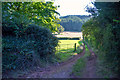
Luccombe : Track
A track heads towards the fields.
Image: © Lewis Clarke
Taken: 17 Sep 2019
0.03 miles
2
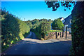
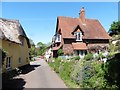
Luccombe : Country Lane
A country lane beside Whychanger Cottage.
Image: © Lewis Clarke
Taken: 17 Sep 2019
0.05 miles
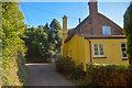
4
Luccombe : Wychanger Cottage
Cottage. C17, enlarged C19 - GV II https://historicengland.org.uk/listing/the-list/list-entry/1057334
Image: © Lewis Clarke
Taken: 17 Sep 2019
0.07 miles
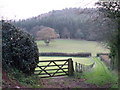
5
Luccombe : Country Lane
A small road passing Three Gates.
Image: © Lewis Clarke
Taken: 17 Sep 2019
0.09 miles
6
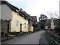
Village houses, main street, Luccombe
Image: © Roger Cornfoot
Taken: 12 Dec 2010
0.09 miles
7
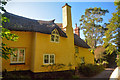
Houses at Luccombe
This is one of the villages owned by the National Trust, part of the Holnicote estate. The houses are all painted in Dorset (sic) cream. I have not discovered the significance of "Hetnor" or "Netnor".
Image: © Graham Horn
Taken: 20 Jul 2010
0.09 miles
8
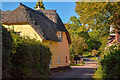
Luccombe : Road
A road through the village. The former post office is on the left.
Image: © Lewis Clarke
Taken: 17 Sep 2019
0.09 miles
10
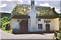
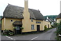
Ketnor, Luccombe Post Office
I've found no geographical mention of Ketnor, but the surname Ketnor is firmly based in Somerset where 2/3 of Ketnor's are found in the UK. Two Ketnors were buried in the village in 1840/41 so this may have been their house? The house name is often mistaken as Hetnor, as it was by me!
The building is possibly 400 years old, or more, and listed Grade II, see; http://list.english-heritage.org.uk/resultsingle.aspx?uid=1174766&searchtype=mapsearch Good to see that it has been renovated since this picture, although this shot maybe more like it will have looked for much of its life.
More about the village at; http://www.localhistories.org/luccombe.html
Image: © Chris Morgan
Taken: Unknown
0.10 miles