IMAGES TAKEN NEAR TO
Hawkcombe, MINEHEAD, TA24 8LW
Introduction
This page details the photographs taken nearby to Hawkcombe, TA24 8LW by members of the Geograph project.
The Geograph project started in 2005 with the aim of publishing, organising and preserving representative images for every square kilometre of Great Britain, Ireland and the Isle of Man.

There are currently over 7.5m images from over14,400 individuals and you can help contribute to the project by visiting https://www.geograph.org.uk
Image Map (Loading...)


Getting Data...Please wait
Leaflet Map data © OpenStreetMap
Images are licensed for reuse under creativecommons.org/licenses/by-sa/2.0
Notes
- Clicking on the map will re-center to the selected point.
- The higher the marker number, the further away the image location is from the centre of the postcode.
Image Listing (14 Images Found)
Images are licensed for reuse under creativecommons.org/licenses/by-sa/2.0
Image
Details
Distance
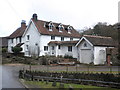
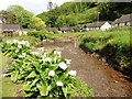
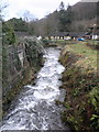
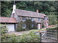
2
Cottages, Hawkcombe
The lane divides at Hawkcombe; the left fork is the through road, turning back to Doverhay. Sunnyside Cottages are above on the right.
Image: © Derek Harper
Taken: 29 Mar 2015
0.01 miles

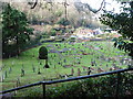
9
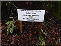
Short stay cemetery
Just the sort of final resting place I'm looking for!
Image: © Roger Cornfoot
Taken: 22 Jan 2016
0.15 miles