IMAGES TAKEN NEAR TO
Doverhay, MINEHEAD, TA24 8LQ
Introduction
This page details the photographs taken nearby to Doverhay, TA24 8LQ by members of the Geograph project.
The Geograph project started in 2005 with the aim of publishing, organising and preserving representative images for every square kilometre of Great Britain, Ireland and the Isle of Man.

There are currently over 7.5m images from over14,400 individuals and you can help contribute to the project by visiting https://www.geograph.org.uk
Image Map
Images are licensed for reuse under creativecommons.org/licenses/by-sa/2.0
Notes
- Clicking on the map will re-center to the selected point.
- The higher the marker number, the further away the image location is from the centre of the postcode.
Image Listing (378 Images Found)
Images are licensed for reuse under creativecommons.org/licenses/by-sa/2.0
Image
Details
Distance
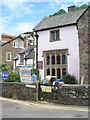
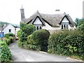
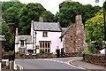
2
Doverhay, Porlock
The house on the left is Locks Cottage.
Image: © John C
Taken: 27 Jun 2019
0.01 miles

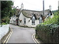
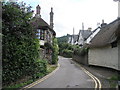
8
Thatched cottage at the junction of Doverhay and The Drang
Image: © John C
Taken: 27 Jun 2019
0.02 miles
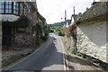
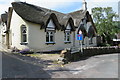
9
Dovery Manor, Porlock, Somerset
Apart from Porlock church, Dovery Manor is the oldest building in Porlock. It dates from the mid 15th century and is now used as a museum.
Image: © Robert Edwards
Taken: 9 Jun 2005
0.02 miles