IMAGES TAKEN NEAR TO
Porlock, MINEHEAD, TA24 8JR
Introduction
This page details the photographs taken nearby to TA24 8JR by members of the Geograph project.
The Geograph project started in 2005 with the aim of publishing, organising and preserving representative images for every square kilometre of Great Britain, Ireland and the Isle of Man.

There are currently over 7.5m images from over14,400 individuals and you can help contribute to the project by visiting https://www.geograph.org.uk
Image Map
Images are licensed for reuse under creativecommons.org/licenses/by-sa/2.0
Notes
- Clicking on the map will re-center to the selected point.
- The higher the marker number, the further away the image location is from the centre of the postcode.
Image Listing (10 Images Found)
Images are licensed for reuse under creativecommons.org/licenses/by-sa/2.0
Image
Details
Distance
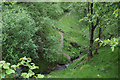
1
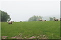
A field of sheep near Broomstreet Farm
The land falls away ahead into Twitchin Combe.
Image: © Bill Boaden
Taken: 24 May 2018
0.04 miles
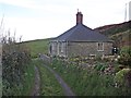
2
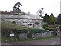
Broomstreet Farm
A really lovely old farmhouse but a long way off the beaten track.
Image: © Barbara Cook
Taken: 30 May 2006
0.05 miles
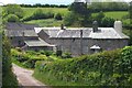
6
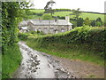
Broomstreet Farm
Broomstreet Farm is passed by the South West Coast Path, here the substantial farmhouse is pictured on a wet day.
Image: © Philip Halling
Taken: 7 Jun 2009
0.09 miles
7
View down Broomstreet valley
A particularly good visibility day, Wales very clear in the background
Image: © Martin Southwood
Taken: 29 May 2007
0.12 miles
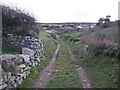
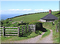
8
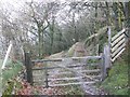
Twitchin Combe
Looking down from the South West Coast Path which is about to cross the combe.
Image: © Bill Boaden
Taken: 24 May 2018
0.19 miles
10
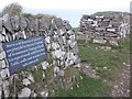
Commemorative plaque on the wall near Twitchin
Image: © Roger Cornfoot
Taken: 4 Dec 2013
0.20 miles