IMAGES TAKEN NEAR TO
Allerford, MINEHEAD, TA24 8HN
Introduction
This page details the photographs taken nearby to TA24 8HN by members of the Geograph project.
The Geograph project started in 2005 with the aim of publishing, organising and preserving representative images for every square kilometre of Great Britain, Ireland and the Isle of Man.

There are currently over 7.5m images from over14,400 individuals and you can help contribute to the project by visiting https://www.geograph.org.uk
Image Map (Loading...)


Getting Data...Please wait
Leaflet Map data © OpenStreetMap
Images are licensed for reuse under creativecommons.org/licenses/by-sa/2.0
Notes
- Clicking on the map will re-center to the selected point.
- The higher the marker number, the further away the image location is from the centre of the postcode.
Image Listing (123 Images Found)
Images are licensed for reuse under creativecommons.org/licenses/by-sa/2.0
Image
Details
Distance
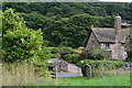
1
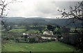
Allerford village
View from path on the edge of Allerford Plantation
Image: © norman griffin
Taken: 6 Apr 1988
0.01 miles
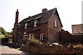
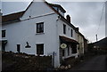
3
House opposite the community orchard at Allerford
Image: © David Martin
Taken: 15 Sep 2018
0.02 miles
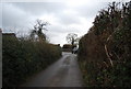

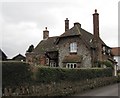
8
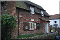
Allerford Post Office
Originally a farmhouse. Grade II listed. http://www.britishlistedbuildings.co.uk/en-265478-allerford-post-office-and-post-box-selwo
Image: © N Chadwick
Taken: 31 Dec 2009
0.03 miles