IMAGES TAKEN NEAR TO
Exford, MINEHEAD, TA24 7QQ
Introduction
This page details the photographs taken nearby to TA24 7QQ by members of the Geograph project.
The Geograph project started in 2005 with the aim of publishing, organising and preserving representative images for every square kilometre of Great Britain, Ireland and the Isle of Man.

There are currently over 7.5m images from over14,400 individuals and you can help contribute to the project by visiting https://www.geograph.org.uk
Image Map (1 Images)


Leaflet Map data © OpenStreetMap
Images are licensed for reuse under creativecommons.org/licenses/by-sa/2.0
Notes
- Clicking on the map will re-center to the selected point.
- The higher the marker number, the further away the image location is from the centre of the postcode.
Image Listing (1 Images Found)
Images are licensed for reuse under creativecommons.org/licenses/by-sa/2.0
Image
Details
Distance
1
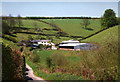
Exford: Coombe Farm
A barn here was water-powered in the 19th century. A long flume or aqueduct was necessary to get the leat water to the wheel, crossing a farm access road. All evidence of this installation has long since disappeared
Image: © Martin Bodman
Taken: 26 May 1996
0.05 miles