IMAGES TAKEN NEAR TO
Exford, MINEHEAD, TA24 7NQ
Introduction
This page details the photographs taken nearby to TA24 7NQ by members of the Geograph project.
The Geograph project started in 2005 with the aim of publishing, organising and preserving representative images for every square kilometre of Great Britain, Ireland and the Isle of Man.

There are currently over 7.5m images from over14,400 individuals and you can help contribute to the project by visiting https://www.geograph.org.uk
Image Map
Images are licensed for reuse under creativecommons.org/licenses/by-sa/2.0
Notes
- Clicking on the map will re-center to the selected point.
- The higher the marker number, the further away the image location is from the centre of the postcode.
Image Listing (8 Images Found)
Images are licensed for reuse under creativecommons.org/licenses/by-sa/2.0
Image
Details
Distance
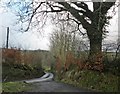
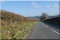
2
Exford: near White Cross
Looking east-north-east towards Exford Common
Image: © Martin Bodman
Taken: 8 Aug 2007
0.20 miles
3
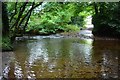
Exford Ford
This is the first of two fords on the River Exe at Exford near Edgcott.
Image: © John Walton
Taken: 20 Sep 2016
0.21 miles
4
Exford Ford
This is the second of the two Exford fords near Edgcott.
Image: © John Walton
Taken: 20 Sep 2016
0.22 miles
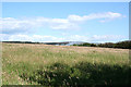
5
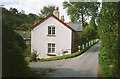
Exford: Lower Mill
By a lane in the Exe valley leading to Westermill and Larkbarrow Corner. Now a private property
Image: © Martin Bodman
Taken: 18 Sep 1993
0.23 miles
7
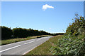
Exford: approaching White Cross
On the B3224 Simonsbath road looking west
Image: © Martin Bodman
Taken: 8 Aug 2007
0.24 miles
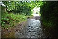
8
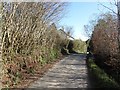
The Tunnel, Edgcott
A single track road on the valley floor. I am not sure where the tunnel is, but the name may refer to the high hedges' effect on visibility in Summer.
Image: © Richard Webb
Taken: 1 Apr 2012
0.25 miles