IMAGES TAKEN NEAR TO
Simonsbath, MINEHEAD, TA24 7LE
Introduction
This page details the photographs taken nearby to TA24 7LE by members of the Geograph project.
The Geograph project started in 2005 with the aim of publishing, organising and preserving representative images for every square kilometre of Great Britain, Ireland and the Isle of Man.

There are currently over 7.5m images from over14,400 individuals and you can help contribute to the project by visiting https://www.geograph.org.uk
Image Map (Loading...)


Getting Data...Please wait
Leaflet Map data © OpenStreetMap
Images are licensed for reuse under creativecommons.org/licenses/by-sa/2.0
Notes
- Clicking on the map will re-center to the selected point.
- The higher the marker number, the further away the image location is from the centre of the postcode.
Image Listing (8 Images Found)
Images are licensed for reuse under creativecommons.org/licenses/by-sa/2.0
Image
Details
Distance
2
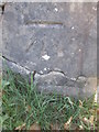
Ordnance Survey Cut Mark
This OS cut mark can be found on the NW parapet of the bridge. It marks a point 421.905m above mean sea level. http://www.geograph.org.uk/photo/4450827
Image: © Adrian Dust
Taken: 22 Apr 2015
0.07 miles
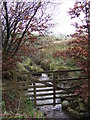
3
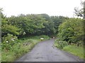
Bridge near Kinsford
Crossing the Kinsford Water, a minor stream that rises on the moor to the right and drains into the River Barle
Image: © David Smith
Taken: 18 Jan 2019
0.07 miles
4
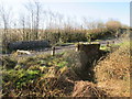
Bridge over Kinsford Water
There is an OS cut mark on the NW parapet. http://www.geograph.org.uk/photo/4450825
Image: © Adrian Dust
Taken: 22 Apr 2015
0.08 miles
6
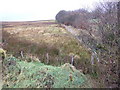
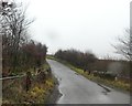
Exmoor by Kinsford
Looking west towards Five Burrows Hill.
Image: © Jonathan Billinger
Taken: 27 Nov 2007
0.09 miles
8
Kinsford Water
One of the feeder streams for the Barle-Exe river system.
Image: © Jonathan Billinger
Taken: 27 Nov 2007
0.13 miles