IMAGES TAKEN NEAR TO
Winsford, MINEHEAD, TA24 7HW
Introduction
This page details the photographs taken nearby to TA24 7HW by members of the Geograph project.
The Geograph project started in 2005 with the aim of publishing, organising and preserving representative images for every square kilometre of Great Britain, Ireland and the Isle of Man.

There are currently over 7.5m images from over14,400 individuals and you can help contribute to the project by visiting https://www.geograph.org.uk
Image Map
Images are licensed for reuse under creativecommons.org/licenses/by-sa/2.0
Notes
- Clicking on the map will re-center to the selected point.
- The higher the marker number, the further away the image location is from the centre of the postcode.
Image Listing (24 Images Found)
Images are licensed for reuse under creativecommons.org/licenses/by-sa/2.0
Image
Details
Distance
1
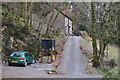
West Somerset : Upcott Cottage
Upcott Cottage and a small drive heading up towards it.
Image: © Lewis Clarke
Taken: 17 Mar 2014
0.01 miles
2
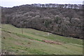
West Somerset : Grassy Hillside
Looking down towards the valley in West Somerset.
Image: © Lewis Clarke
Taken: 17 Mar 2014
0.03 miles
3
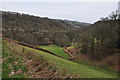
West Somerset : Countryside Scenery
Looking down the hillside and into the valley.
Image: © Lewis Clarke
Taken: 17 Mar 2014
0.07 miles
4

Quarme Bridge, Upcott Lane
The River Quarme is a left bank tributary of the River Exe and it is crossed here by Upcott Lane at the eponymously named bridge. The lane will take you to Winsford.
Image: © Alan Bowring
Taken: 6 Apr 2007
0.08 miles
5
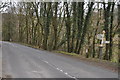
West Somerset : The A396
The A396 heading through West Somerset.
Image: © Lewis Clarke
Taken: 17 Mar 2014
0.10 miles
6
West Somerset : A396 Signpost
II Milestone. Early C19. Sandstone and cast iron. Cambered head stone about 700 mm high, attached cast iron plaque, semi-circular central section to head inscribed with incised lettering: '11 miles to Minehead'. The road was turnpiked in 1824.
Image: © Lewis Clarke
Taken: 17 Mar 2014
0.10 miles
7
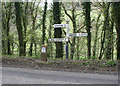
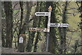
Old Direction Sign - Signpost by the A396, Exton Parish
Pyramid finial - 4 arms; Somerset SCC pyramid by the A396, in parish of Exton (West Somerset District), junction with Quarme Lane, a UC road running up into the woodland, next to milestone - Image
Surveyed
Milestone Society National ID: SO_SS9136
Image: © Alan Rosevear
Taken: 3 May 2010
0.10 miles
8
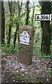
Old Milestone by the A396, Quarme Wood, Exton Parish
Metal plate attached to stone post by the A396, in parish of EXTON (WEST SOMERSET District), junction with Quarme Lane, UC road running up into the woodland. Set in granite chips on verge, beside the fingerpost, on West side of road. Minehead iron plate, erected by the Minehead & Bampton Road turnpike trust in the 19th century.
Inscription reads:-
11
MILES
To
Minehead
Rivet on top.
Grade II Listed.
List Entry Number: 1345376 https://historicengland.org.uk/listing/the-list/list-entry/1345376
Adjacent fingerpost is: SO_SS9136 Image
Milestone Society National ID: SO_MHEB11.
Image: © A Rosevear
Taken: 3 May 2010
0.10 miles
9

West Somerset : The A396
The A396 heading through the West Somerset countryside.
Image: © Lewis Clarke
Taken: 19 Oct 2013
0.11 miles
10
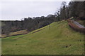
West Somerset : Grassy Hillside
A grassy hillside in the West Somerset countryside.
Image: © Lewis Clarke
Taken: 17 Mar 2014
0.11 miles