IMAGES TAKEN NEAR TO
Cutcombe, MINEHEAD, TA24 7AL
Introduction
This page details the photographs taken nearby to TA24 7AL by members of the Geograph project.
The Geograph project started in 2005 with the aim of publishing, organising and preserving representative images for every square kilometre of Great Britain, Ireland and the Isle of Man.

There are currently over 7.5m images from over14,400 individuals and you can help contribute to the project by visiting https://www.geograph.org.uk
Image Map
Images are licensed for reuse under creativecommons.org/licenses/by-sa/2.0
Notes
- Clicking on the map will re-center to the selected point.
- The higher the marker number, the further away the image location is from the centre of the postcode.
Image Listing (4 Images Found)
Images are licensed for reuse under creativecommons.org/licenses/by-sa/2.0
Image
Details
Distance
1
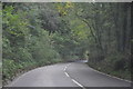
West Somerset : The A396
The A396 heading through West Somerset.
Image: © Lewis Clarke
Taken: 19 Oct 2013
0.13 miles
2
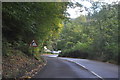
West Somerset : The A396
The A396 heading through the West Somerset countryside.
Image: © Lewis Clarke
Taken: 19 Oct 2013
0.21 miles
3
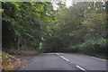
West Somerset : The A396
The A396 heading through West Somerset.
Image: © Lewis Clarke
Taken: 19 Oct 2013
0.24 miles
4
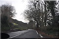
West Somerset : The A396
The A396 between Timberscombe and Wheddon Cross.
Image: © Lewis Clarke
Taken: 12 Feb 2011
0.24 miles