IMAGES TAKEN NEAR TO
West Close, MINEHEAD, TA24 6SA
Introduction
This page details the photographs taken nearby to West Close, TA24 6SA by members of the Geograph project.
The Geograph project started in 2005 with the aim of publishing, organising and preserving representative images for every square kilometre of Great Britain, Ireland and the Isle of Man.

There are currently over 7.5m images from over14,400 individuals and you can help contribute to the project by visiting https://www.geograph.org.uk
Image Map (Loading...)


Getting Data...Please wait
Leaflet Map data © OpenStreetMap
Images are licensed for reuse under creativecommons.org/licenses/by-sa/2.0
Notes
- Clicking on the map will re-center to the selected point.
- The higher the marker number, the further away the image location is from the centre of the postcode.
Image Listing (849 Images Found)
Images are licensed for reuse under creativecommons.org/licenses/by-sa/2.0
Image
Details
Distance
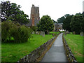
2
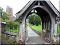
Lych Gate, Dunster Parish Church
Looking from Priory Green.
Image: © Phil Champion
Taken: 16 Jul 2009
0.02 miles
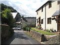
3
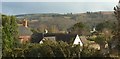
View over Dunster
The roofs of houses on St George's Street, with a view across the Avill valley towards woods in Dunster Deer Park.
Image: © Derek Harper
Taken: 9 Apr 2016
0.02 miles
5
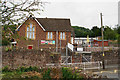
Dunster First School
The village primary school for ages 4 to 9.
Image: © Bill Boaden
Taken: 27 Jun 2017
0.03 miles
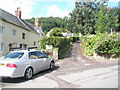
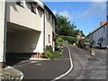
7
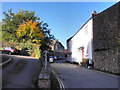
Junction of St George's Street and West Close, Dunster
Image: © Roger Cornfoot
Taken: 27 Oct 2010
0.03 miles