IMAGES TAKEN NEAR TO
Orchard Road, MINEHEAD, TA24 6NW
Introduction
This page details the photographs taken nearby to Orchard Road, TA24 6NW by members of the Geograph project.
The Geograph project started in 2005 with the aim of publishing, organising and preserving representative images for every square kilometre of Great Britain, Ireland and the Isle of Man.

There are currently over 7.5m images from over14,400 individuals and you can help contribute to the project by visiting https://www.geograph.org.uk
Image Map (Loading...)


Getting Data...Please wait
Leaflet Map data © OpenStreetMap
Images are licensed for reuse under creativecommons.org/licenses/by-sa/2.0
Notes
- Clicking on the map will re-center to the selected point.
- The higher the marker number, the further away the image location is from the centre of the postcode.
Image Listing (89 Images Found)
Images are licensed for reuse under creativecommons.org/licenses/by-sa/2.0
Image
Details
Distance
6
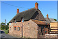
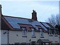
Thatched Cottage
Cottage in Carhampton.
Image: © Wayland Smith
Taken: 27 Aug 2017
0.05 miles
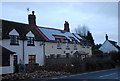
8

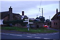
Eastbury Farm, Carhampton
At present the farm is not working and up for sale - £391,000
Image: © John C
Taken: 26 Jun 2019
0.06 miles
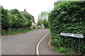
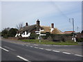
9
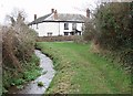
Eastbury Farm
Taken looking north from the footpath that loops back toward the main A39. The road in front of the house is Eastbury Hill, the B3191.
Image: © Barbara Cook
Taken: 16 Jan 2006
0.06 miles