IMAGES TAKEN NEAR TO
Dunster Steep, MINEHEAD, TA24 6FD
Introduction
This page details the photographs taken nearby to Dunster Steep, TA24 6FD by members of the Geograph project.
The Geograph project started in 2005 with the aim of publishing, organising and preserving representative images for every square kilometre of Great Britain, Ireland and the Isle of Man.

There are currently over 7.5m images from over14,400 individuals and you can help contribute to the project by visiting https://www.geograph.org.uk
Image Map (Loading...)


Getting Data...Please wait
Leaflet Map data © OpenStreetMap
Images are licensed for reuse under creativecommons.org/licenses/by-sa/2.0
Notes
- Clicking on the map will re-center to the selected point.
- The higher the marker number, the further away the image location is from the centre of the postcode.
Image Listing (426 Images Found)
Images are licensed for reuse under creativecommons.org/licenses/by-sa/2.0
Image
Details
Distance
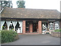
2
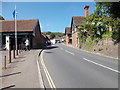
Dunster Steep - looking up from Car Park
Image: © Betty Longbottom
Taken: 8 May 2017
0.03 miles
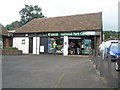

6
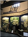
Display of Exmoor life within Dunster Visitor Centre
Image: © Basher Eyre
Taken: 2 Aug 2008
0.04 miles

8
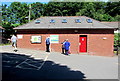
Dunster public toilets
At the edge of the car park on the south side of the A396 which is here named
Dunster Steep. Viewed on July 1st 2017 when it cost 20 pence to use these toilets.
Image: © Jaggery
Taken: 1 Jul 2017
0.04 miles
9
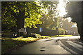
Dunster : Dunster Step
Dunster Step as you approach the picturesque village of Dunster.
Image: © Lewis Clarke
Taken: 19 Oct 2013
0.04 miles