IMAGES TAKEN NEAR TO
Combeland Road, MINEHEAD, TA24 6BT
Introduction
This page details the photographs taken nearby to Combeland Road, TA24 6BT by members of the Geograph project.
The Geograph project started in 2005 with the aim of publishing, organising and preserving representative images for every square kilometre of Great Britain, Ireland and the Isle of Man.

There are currently over 7.5m images from over14,400 individuals and you can help contribute to the project by visiting https://www.geograph.org.uk
Image Map (Loading...)


Getting Data...Please wait
Leaflet Map data © OpenStreetMap
Images are licensed for reuse under creativecommons.org/licenses/by-sa/2.0
Notes
- Clicking on the map will re-center to the selected point.
- The higher the marker number, the further away the image location is from the centre of the postcode.
Image Listing (41 Images Found)
Images are licensed for reuse under creativecommons.org/licenses/by-sa/2.0
Image
Details
Distance
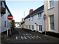
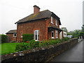
1
Combeland Road, Alcombe
The rural side of a village that is being slowly absorbed into Minehead town.
Image: © Peter Turner
Taken: 29 Oct 2011
0.02 miles
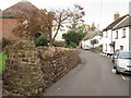
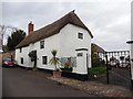
3
The Hermitage, Alcombe
An attractive old thatched farmhouse(?) and gardens visible from the gateway.
Image: © Peter Turner
Taken: 29 Oct 2011
0.05 miles
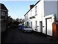
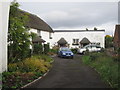
9

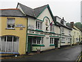
Minehead : Manor Road
The Britannia Pub seen here on the right.
Image: © Lewis Clarke
Taken: 2 May 2016
0.14 miles