IMAGES TAKEN NEAR TO
Ingrams Meadow, WATCHET, TA23 0EU
Introduction
This page details the photographs taken nearby to Ingrams Meadow, TA23 0EU by members of the Geograph project.
The Geograph project started in 2005 with the aim of publishing, organising and preserving representative images for every square kilometre of Great Britain, Ireland and the Isle of Man.

There are currently over 7.5m images from over14,400 individuals and you can help contribute to the project by visiting https://www.geograph.org.uk
Image Map (Loading...)


Getting Data...Please wait
Leaflet Map data © OpenStreetMap
Images are licensed for reuse under creativecommons.org/licenses/by-sa/2.0
Notes
- Clicking on the map will re-center to the selected point.
- The higher the marker number, the further away the image location is from the centre of the postcode.
Image Listing (8 Images Found)
Images are licensed for reuse under creativecommons.org/licenses/by-sa/2.0
Image
Details
Distance
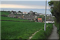
1
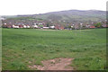
Watchet's South Road/Woodlands Road area
With the Staple Plain area of the Quantock Hills on the skyline. Taken from the St. Decuman's Road to Parsonage Farm footpath. The light industrial units - on the other side of the field - are on the site of a former gasworks, whose gasholders were demolished some years back. I can remember South Wales coke being imported through Watchet Harbour, back in the early 1960s, to produce the gas at this site.
Image: © Stephen Wilks
Taken: 1 May 2010
0.14 miles
2
Channel to Channel (528)
This is looking east along the path on the southern edge of Watchet.
Image: © Shazz
Taken: 2 May 2015
0.15 miles
3
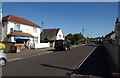
Liddymore Road, Watchet
A fish and chip shop, which has as near neighbours a supermarket and a cafe. Beyond, the road becomes residential.
Image: © Derek Harper
Taken: 24 May 2010
0.16 miles
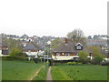
4
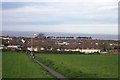
Watchet from the South.
The well used footpath from Williton affords good views of the town and the Bristol Channel beyond. In the far distance is the Welsh Coast.
Image: © Barbara Cook
Taken: 16 Nov 2005
0.16 miles
5
Watchet's back door
The top of Woodlands Road in the middle ground. St. Decuman's Road on the ridge and the South Wales coast on the horizon.
Image: © Stephen Wilks
Taken: 5 May 2010
0.18 miles
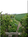
6
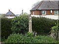
Channel to Channel (527)
This waymark is at the path crossing on the southern edge of Watchet.
Image: © Shazz
Taken: 2 May 2015
0.18 miles
7
Channel to Channel (526)
The path continues between crops to the edge of Watchet. The first geograph for this square is similar - see http://www.geograph.org.uk/photo/79434.
Image: © Shazz
Taken: 2 May 2015
0.19 miles
8
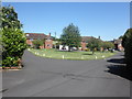
Housing estate, at the eastern edge of Watchet
Image: © Roger Cornfoot
Taken: 19 Jul 2012
0.23 miles