IMAGES TAKEN NEAR TO
DULVERTON, TA22 9PT
Introduction
This page details the photographs taken nearby to TA22 9PT by members of the Geograph project.
The Geograph project started in 2005 with the aim of publishing, organising and preserving representative images for every square kilometre of Great Britain, Ireland and the Isle of Man.

There are currently over 7.5m images from over14,400 individuals and you can help contribute to the project by visiting https://www.geograph.org.uk
Image Map
Images are licensed for reuse under creativecommons.org/licenses/by-sa/2.0
Notes
- Clicking on the map will re-center to the selected point.
- The higher the marker number, the further away the image location is from the centre of the postcode.
Image Listing (9 Images Found)
Images are licensed for reuse under creativecommons.org/licenses/by-sa/2.0
Image
Details
Distance
2
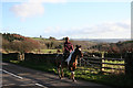
Dulverton: horse and rider at Highercombe
Looking south-south-east on the B3223 Dulverton-Simonsbath road
Image: © Martin Bodman
Taken: 10 Jan 2007
0.07 miles
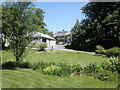
4
Dulverton: by Highercombe
Looking south-south-east in the direction of Dulverton. The water channel is thought to be the tail race from a water-powered threshing barn at Highercombe
Image: © Martin Bodman
Taken: 10 Jan 2007
0.13 miles
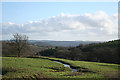
7
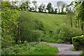
West Somerset : The B3223 & Field
A field overlooking the B3223 in West Somerset.
Image: © Lewis Clarke
Taken: 26 May 2014
0.24 miles
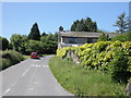
9
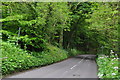
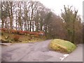
West Somerset : The B3223
Looking along the B3223 as it heads through West Somerset.
Image: © Lewis Clarke
Taken: 26 May 2014
0.25 miles