IMAGES TAKEN NEAR TO
Brompton Regis, DULVERTON, TA22 9LQ
Introduction
This page details the photographs taken nearby to TA22 9LQ by members of the Geograph project.
The Geograph project started in 2005 with the aim of publishing, organising and preserving representative images for every square kilometre of Great Britain, Ireland and the Isle of Man.

There are currently over 7.5m images from over14,400 individuals and you can help contribute to the project by visiting https://www.geograph.org.uk
Image Map (Loading...)


Getting Data...Please wait
Leaflet Map data © OpenStreetMap
Images are licensed for reuse under creativecommons.org/licenses/by-sa/2.0
Notes
- Clicking on the map will re-center to the selected point.
- The higher the marker number, the further away the image location is from the centre of the postcode.
Image Listing (5 Images Found)
Images are licensed for reuse under creativecommons.org/licenses/by-sa/2.0
Image
Details
Distance
1
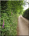
Hownel Lane
Foxgloves beside the lane as it climbs from the Exe valley. Image] shows a view from here towards the valley.
Image: © Derek Harper
Taken: 26 Jun 2013
0.09 miles
2
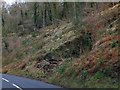
Clearance in Kent's Wood
This deep depression appears to have been a former quarry
Image: © David Smith
Taken: 15 Feb 2013
0.14 miles
3
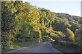
West Somerset : The A396
The A396 heading through West Somerset.
Image: © Lewis Clarke
Taken: 19 Oct 2013
0.17 miles
4
West Somerset : The A396
The A396 heading through West Somerset.
Image: © Lewis Clarke
Taken: 19 Oct 2013
0.18 miles
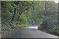
5
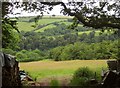
Towards the Exe valley
From the same spot as Image], looking down a narrow field of grass to the valley carrying the A396 to Minehead. Beyond is a short combe beside Broford Farm.
Image: © Derek Harper
Taken: 26 Jun 2013
0.21 miles