IMAGES TAKEN NEAR TO
Bridgetown, DULVERTON, TA22 9JL
Introduction
This page details the photographs taken nearby to TA22 9JL by members of the Geograph project.
The Geograph project started in 2005 with the aim of publishing, organising and preserving representative images for every square kilometre of Great Britain, Ireland and the Isle of Man.

There are currently over 7.5m images from over14,400 individuals and you can help contribute to the project by visiting https://www.geograph.org.uk
Image Map
Images are licensed for reuse under creativecommons.org/licenses/by-sa/2.0
Notes
- Clicking on the map will re-center to the selected point.
- The higher the marker number, the further away the image location is from the centre of the postcode.
Image Listing (80 Images Found)
Images are licensed for reuse under creativecommons.org/licenses/by-sa/2.0
Image
Details
Distance
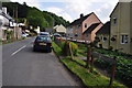
1
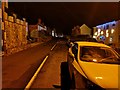
Bridgetown : The A396
A road heading through the hamlet.
Image: © Lewis Clarke
Taken: 9 Dec 2018
0.00 miles
2

Bridgetown : A396
A road through the village.
Image: © Lewis Clarke
Taken: 1 Jun 2021
0.01 miles
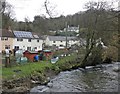
3
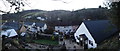
Bridgetown : Village Scenery
Bridgetown is a small hamlet in West Somerset.
Image: © Lewis Clarke
Taken: 9 Feb 2018
0.01 miles
4

Bridgetown : Snowman
A snowman beside the River Exe.
Image: © Lewis Clarke
Taken: 4 Mar 2018
0.02 miles
5
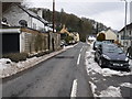
Bridgetown : The A396
The main road through the hamlet of Bridgetown.
Image: © Lewis Clarke
Taken: 4 Mar 2018
0.02 miles
6
Bridgetown : The A396
A road through Bridgetown.
Image: © Lewis Clarke
Taken: 16 Jun 2019
0.02 miles
7
Bridgetown : The A396
A road heading through the small village of Bridgetown.
Image: © Lewis Clarke
Taken: 15 Jun 2014
0.02 miles
9
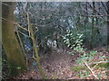
Bridgetown : Woodland
A small woodland patch in Bridgetown.
Image: © Lewis Clarke
Taken: 9 Feb 2018
0.02 miles
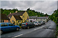
10
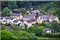
West Somerset : Bridgetown Scenery
Looking down towards the small village of Bridgetown.
Image: © Lewis Clarke
Taken: 15 Jun 2014
0.02 miles