IMAGES TAKEN NEAR TO
Millham Lane, DULVERTON, TA22 9HQ
Introduction
This page details the photographs taken nearby to Millham Lane, TA22 9HQ by members of the Geograph project.
The Geograph project started in 2005 with the aim of publishing, organising and preserving representative images for every square kilometre of Great Britain, Ireland and the Isle of Man.

There are currently over 7.5m images from over14,400 individuals and you can help contribute to the project by visiting https://www.geograph.org.uk
Image Map (Loading...)


Getting Data...Please wait
Leaflet Map data © OpenStreetMap
Images are licensed for reuse under creativecommons.org/licenses/by-sa/2.0
Notes
- Clicking on the map will re-center to the selected point.
- The higher the marker number, the further away the image location is from the centre of the postcode.
Image Listing (227 Images Found)
Images are licensed for reuse under creativecommons.org/licenses/by-sa/2.0
Image
Details
Distance
1
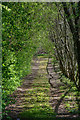
Dulverton : Track
A track off Millham Lane.
Image: © Lewis Clarke
Taken: 4 May 2019
0.02 miles


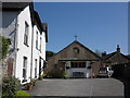
5
Offices of the Exmoor Society, Dulverton
Image: © Roger Cornfoot
Taken: 17 Apr 2019
0.08 miles
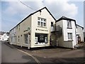
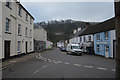
7

Dulverton : Abbotts Way
A footpath through Dulverton.
Image: © Lewis Clarke
Taken: 18 Nov 2023
0.08 miles
8
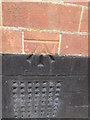
Ordnance Survey Cut Mark
This OS cut mark can be found on the NE face Of Lambs Court. It marks a point 140.080m above mean sea level.
Image: © Adrian Dust
Taken: 25 Apr 2015
0.08 miles
9
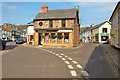
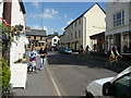
Dulverton : High Street
A road heading through Dulverton.
Image: © Lewis Clarke
Taken: 24 Mar 2017
0.08 miles