IMAGES TAKEN NEAR TO
Winsham, CHARD, TA20 4JT
Introduction
This page details the photographs taken nearby to TA20 4JT by members of the Geograph project.
The Geograph project started in 2005 with the aim of publishing, organising and preserving representative images for every square kilometre of Great Britain, Ireland and the Isle of Man.

There are currently over 7.5m images from over14,400 individuals and you can help contribute to the project by visiting https://www.geograph.org.uk
Image Map
Images are licensed for reuse under creativecommons.org/licenses/by-sa/2.0
Notes
- Clicking on the map will re-center to the selected point.
- The higher the marker number, the further away the image location is from the centre of the postcode.
Image Listing (4 Images Found)
Images are licensed for reuse under creativecommons.org/licenses/by-sa/2.0
Image
Details
Distance
2
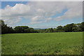
Fields at Kingstonwell
The woods on the far side of this field of grass is Kingstonwell Plantation.
Image: © Nigel Mykura
Taken: 26 May 2017
0.19 miles
3
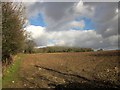
Towards High Wood
From a gateway by the junction at which Image] was taken, with the B3167 to Crewkerne behind the hedge on the left. High Wood is ahead.
Image: © Derek Harper
Taken: 24 Feb 2015
0.21 miles
4
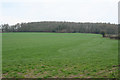
Winsham: Fosse Way near High Wood
By a place named ‘Street’: the Fosse Way ran from the left hand edge of High Wood - ahead - towards the camera. Looking north east
Image: © Martin Bodman
Taken: 16 Apr 2006
0.23 miles