IMAGES TAKEN NEAR TO
Chaffcombe, CHARD, TA20 4AL
Introduction
This page details the photographs taken nearby to TA20 4AL by members of the Geograph project.
The Geograph project started in 2005 with the aim of publishing, organising and preserving representative images for every square kilometre of Great Britain, Ireland and the Isle of Man.

There are currently over 7.5m images from over14,400 individuals and you can help contribute to the project by visiting https://www.geograph.org.uk
Image Map
Images are licensed for reuse under creativecommons.org/licenses/by-sa/2.0
Notes
- Clicking on the map will re-center to the selected point.
- The higher the marker number, the further away the image location is from the centre of the postcode.
Image Listing (9 Images Found)
Images are licensed for reuse under creativecommons.org/licenses/by-sa/2.0
Image
Details
Distance
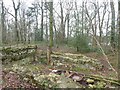
1
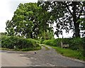
Turning for Greenways and Walscombe Farms
Image: © Roger Cornfoot
Taken: 6 Jul 2016
0.12 miles
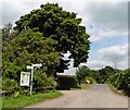
3
Grantchester Meadows
This is the location of a sizeable poultry farm behind the trees on the left. The scarecrow standing at the road junction is advertising a local Whist Drive.
Image: © Nigel Mykura
Taken: 6 Mar 2020
0.15 miles
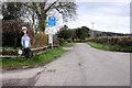
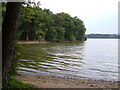
4

Chard: Chard Reservoir
The north-eastern end of the lake. It was originally created in 1839-1842 to provide power for a water turbine, to work the Chard Common Incline on the canal, linking the town with the Taunton-Bridgwater Canal. The canal was a latecomer and had a short life: it was abandoned in 1866. Since 1990, when the reservoir was given to the district council, it has been transformed into a Local Nature Reserve, popular with anglers
Image: © Martin Bodman
Taken: 21 Aug 2011
0.19 miles
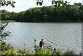
5
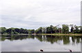
Chard Reservoir
Across the water at Chard reservoir
Image: © Julie Munckton
Taken: 27 Jul 2013
0.19 miles
6
Ruined boathouse by Chard Reservoir
Restored by the rangers in this nature reserve
Image: © David Smith
Taken: 30 Dec 2019
0.20 miles
7
Chard: Chard Reservoir
A reservoir built in 1839-42 to power an incline on the Chard Canal. Now a local nature reserve managed by the district council and popular with anglers. See Image for more details
Image: © Martin Bodman
Taken: 21 Aug 2011
0.21 miles
8
Chard Reservoir
The northeast corner of the reservoir. See Image I think that's a Great Crested Grebe near the far shore.
Image: © Derek Harper
Taken: 21 Sep 2006
0.22 miles
9
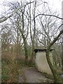
The eco-toilet (composting toilet) by Chard Reservoir
This toilet is dry and uses sawdust to cover faeces. There are two "holes", used alternately. It is close to the car-park for anglers
Image: © David Smith
Taken: 30 Dec 2019
0.23 miles