IMAGES TAKEN NEAR TO
Newtown, CHARD, TA20 3TF
Introduction
This page details the photographs taken nearby to Newtown, TA20 3TF by members of the Geograph project.
The Geograph project started in 2005 with the aim of publishing, organising and preserving representative images for every square kilometre of Great Britain, Ireland and the Isle of Man.

There are currently over 7.5m images from over14,400 individuals and you can help contribute to the project by visiting https://www.geograph.org.uk
Image Map
Images are licensed for reuse under creativecommons.org/licenses/by-sa/2.0
Notes
- Clicking on the map will re-center to the selected point.
- The higher the marker number, the further away the image location is from the centre of the postcode.
Image Listing (11 Images Found)
Images are licensed for reuse under creativecommons.org/licenses/by-sa/2.0
Image
Details
Distance


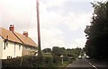
3

A303 heading west
Through Newtown, a hamlet rather than a town.
Image: © Robin Webster
Taken: 7 Sep 2019
0.03 miles
4

Buckland St Mary: The Old Smithy, Newtown
The property extends down to the A30 Trunk Road. William Stone, a wheelwright and carpenter, operated here from at least 1836 until his death sometime before 1851. The smithy itself stood in the fork of the main road and this lane. The business continued in existence until the 1940s.
[Source: Derrick Warren. Under the Spreading Chestnut Tree. Article in Bulletin 78, of the Somerset Industrial Archaeological Society, August 1998]
Image: © Martin Bodman
Taken: 29 Aug 2006
0.07 miles


7

A303 on the west of Newtown
The derelict building on the right was labelled Newtown Garage and General Store, but some of the letters have slipped and are missing, so the words are incomplete.
Image: © David Smith
Taken: 2 May 2012
0.10 miles
8

Old Milestone by the A303, Buckland St Mary Parish
Metal plate attached to stone post by the A303, in parish of BUCKLAND ST MARY (SOUTH SOMERSET District), Newtown, by Newtown Farm, garage, built into end corner of stone wall, facing Honiton, on North side of road. Ilminster iron plate, erected by the Honiton & Ilminster turnpike trust in the 19th century.
Inscription reads:-
: (ILMINSTER / 6) : : HONITON / 10½ :
Grade II listed. List Entry Number: 1277950 https://historicengland.org.uk/listing/the-list/list-entry/1277950
Milestone Society National ID: SO_IMHO06.
Image: © Alan Rosevear
Taken: 2 Mar 2011
0.11 miles