IMAGES TAKEN NEAR TO
Bishopswood, CHARD, TA20 3RY
Introduction
This page details the photographs taken nearby to TA20 3RY by members of the Geograph project.
The Geograph project started in 2005 with the aim of publishing, organising and preserving representative images for every square kilometre of Great Britain, Ireland and the Isle of Man.

There are currently over 7.5m images from over14,400 individuals and you can help contribute to the project by visiting https://www.geograph.org.uk
Image Map
Images are licensed for reuse under creativecommons.org/licenses/by-sa/2.0
Notes
- Clicking on the map will re-center to the selected point.
- The higher the marker number, the further away the image location is from the centre of the postcode.
Image Listing (7 Images Found)
Images are licensed for reuse under creativecommons.org/licenses/by-sa/2.0
Image
Details
Distance
1
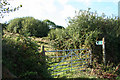
Yarcombe: footpath to North Common
Looking north west on the lane to Clifthayne Farm
Image: © Martin Bodman
Taken: 29 Aug 2006
0.09 miles
2
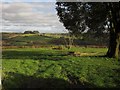
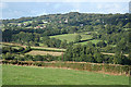
Meadow above the Yarty valley
Taken a little further down the lane seen in Image, with the Yarty valley in the background, and what looks like a holm oak on the right.
Image: © Derek Harper
Taken: 25 Feb 2012
0.17 miles
3
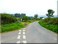
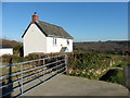
Channel to Channel (197)
A road junction is passed and there is a cottage ahead.
Image: © Shazz
Taken: 17 Sep 2014
0.18 miles
4
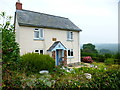
Channel to Channel (198)
This cottage has a plaque which is not easy to read but the guide book tells me it commemorates its building by a descendant of Sir Francis Drake in 1812.
Image: © Shazz
Taken: 17 Sep 2014
0.19 miles
6
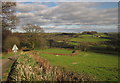
Yarcombe: the Yarty valley
Looking north east over the valley towards Buckland St Mary church which stands on the wooded hill beyond
Image: © Martin Bodman
Taken: 29 Aug 2006
0.19 miles
7
Towards the Yarty valley
The lane descends the western slopes of the Yarty valley. Cinder Hill Farm, across the valley on the right, is in Image, as is the woodland left of centre on Longlie Common.
Image: © Derek Harper
Taken: 25 Feb 2012
0.20 miles