IMAGES TAKEN NEAR TO
Birchwood, CHARD, TA20 3QH
Introduction
This page details the photographs taken nearby to TA20 3QH by members of the Geograph project.
The Geograph project started in 2005 with the aim of publishing, organising and preserving representative images for every square kilometre of Great Britain, Ireland and the Isle of Man.

There are currently over 7.5m images from over14,400 individuals and you can help contribute to the project by visiting https://www.geograph.org.uk
Image Map
Images are licensed for reuse under creativecommons.org/licenses/by-sa/2.0
Notes
- Clicking on the map will re-center to the selected point.
- The higher the marker number, the further away the image location is from the centre of the postcode.
Image Listing (18 Images Found)
Images are licensed for reuse under creativecommons.org/licenses/by-sa/2.0
Image
Details
Distance
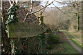
1
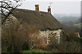
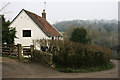
Lane junction, Birchwood
I think Image must have been taken from the gate on the right, though the farm is mapped as Reddie Hill Farm. The lane by it is Blind Lane.
Image: © Derek Harper
Taken: 7 May 2011
0.07 miles
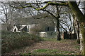
4
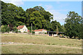
Otterford: Christmas Farm
At Birch Wood, looking east-north-east
Image: © Martin Bodman
Taken: 21 Aug 2006
0.09 miles
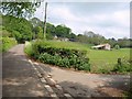
5
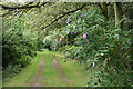
Otterford: bridleway to Owlhayes
Looking north west along a track open to the public
Image: © Martin Bodman
Taken: 21 Aug 2006
0.09 miles
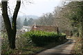
9
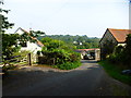
Channel to Channel (234)
This is Waterhayes Lane looking downhill from the farm.
See also http://www.geograph.org.uk/photo/2830382 from 2012.
Image: © Shazz
Taken: 17 Sep 2014
0.13 miles