IMAGES TAKEN NEAR TO
Ham, Combe St. Nicholas, CHARD, TA20 3HX
Introduction
This page details the photographs taken nearby to TA20 3HX by members of the Geograph project.
The Geograph project started in 2005 with the aim of publishing, organising and preserving representative images for every square kilometre of Great Britain, Ireland and the Isle of Man.

There are currently over 7.5m images from over14,400 individuals and you can help contribute to the project by visiting https://www.geograph.org.uk
Image Map
Images are licensed for reuse under creativecommons.org/licenses/by-sa/2.0
Notes
- Clicking on the map will re-center to the selected point.
- The higher the marker number, the further away the image location is from the centre of the postcode.
Image Listing (8 Images Found)
Images are licensed for reuse under creativecommons.org/licenses/by-sa/2.0
Image
Details
Distance
5
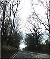
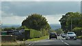
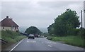
A303 south of Plyer's Hill
The road is tree-lined for a short distance. Older OS maps mark this as a cutting but the latest ones do not consider it deep enough!
Image: © David Smith
Taken: 2 May 2012
0.20 miles
7
St Barnabas Church, Ham
The gable has a plaque giving a date of 1903. "As the Mission Church of St Barnabas, Ham, has no electricity, services are only held in the summer" http://www.combestnicholas.org.uk/about_the_parish/Church%20Annual%20report%202010 .
Image: © Derek Harper
Taken: 7 May 2011
0.23 miles
8
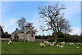
St. Barnabas church at Ham
Bearing the date 1903.
Image: © Nick Chipchase
Taken: 29 Apr 2016
0.23 miles