IMAGES TAKEN NEAR TO
Wambrook, CHARD, TA20 3ED
Introduction
This page details the photographs taken nearby to TA20 3ED by members of the Geograph project.
The Geograph project started in 2005 with the aim of publishing, organising and preserving representative images for every square kilometre of Great Britain, Ireland and the Isle of Man.

There are currently over 7.5m images from over14,400 individuals and you can help contribute to the project by visiting https://www.geograph.org.uk
Image Map
Images are licensed for reuse under creativecommons.org/licenses/by-sa/2.0
Notes
- Clicking on the map will re-center to the selected point.
- The higher the marker number, the further away the image location is from the centre of the postcode.
Image Listing (4 Images Found)
Images are licensed for reuse under creativecommons.org/licenses/by-sa/2.0
Image
Details
Distance
1
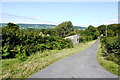
Shell's Lane
Shell's lane runs down the steep slope from Mancroft down to Southay cross on the A30 next to Cleave Hill.
Image: © Nigel Mykura
Taken: 7 Aug 2015
0.04 miles
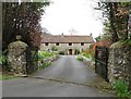
3
Pasture by Shell's Lane
Shell's Lane runs along the far side of this triangular fan-shaped field, seen here from the road shown in Image
Image: © Derek Harper
Taken: 25 Feb 2012
0.08 miles
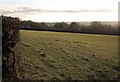
4
Field at Weston Corner
Although this pasture field is fairly flat on the ridge of the hill it drops quite steeply down to the road at Mancroft.
Image: © Nigel Mykura
Taken: 7 Aug 2015
0.16 miles