IMAGES TAKEN NEAR TO
Howley, CHARD, TA20 3EA
Introduction
This page details the photographs taken nearby to TA20 3EA by members of the Geograph project.
The Geograph project started in 2005 with the aim of publishing, organising and preserving representative images for every square kilometre of Great Britain, Ireland and the Isle of Man.

There are currently over 7.5m images from over14,400 individuals and you can help contribute to the project by visiting https://www.geograph.org.uk
Image Map
Images are licensed for reuse under creativecommons.org/licenses/by-sa/2.0
Notes
- Clicking on the map will re-center to the selected point.
- The higher the marker number, the further away the image location is from the centre of the postcode.
Image Listing (6 Images Found)
Images are licensed for reuse under creativecommons.org/licenses/by-sa/2.0
Image
Details
Distance
1
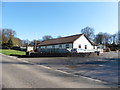
Entrance, South Somerset Holiday and Residential Park
Image: © Roger Cornfoot
Taken: 15 Mar 2017
0.08 miles
2
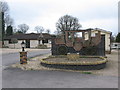
Turnpike Caravan Park
A view looking to the southwest at the entrance to the Turnpike Caravan Park, showing the novel brick stagecoach and the arrivals area.
Image: © Phil Williams
Taken: 30 Apr 2006
0.10 miles
3
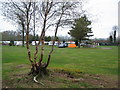
Turnpike Caravan Park
A view looking to the north to the touring caravans and a solitary tent at the Turnpike Caravan Park. The amenities building is at the right.
Image: © Phil Williams
Taken: 30 Apr 2006
0.10 miles
4
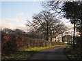
Road past Turnpike Caravan Park
The road south from the A30 to Membury, with the southern edge of the caravan site on the right.
Image: © Derek Harper
Taken: 25 Feb 2012
0.11 miles
5
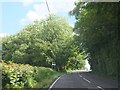
A30 on Cleave Hill
On the further side of the woodland on the left, a minor road leads to Howley; the road signs give advance warning of the turn.
Image: © David Smith
Taken: 5 Jun 2014
0.21 miles
6
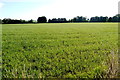
Grass Field
This large field of grass is just off the A30 between Whitestaunton and Crawley
Image: © Nigel Mykura
Taken: 7 Aug 2015
0.23 miles