IMAGES TAKEN NEAR TO
Whitestaunton, CHARD, TA20 3DP
Introduction
This page details the photographs taken nearby to TA20 3DP by members of the Geograph project.
The Geograph project started in 2005 with the aim of publishing, organising and preserving representative images for every square kilometre of Great Britain, Ireland and the Isle of Man.

There are currently over 7.5m images from over14,400 individuals and you can help contribute to the project by visiting https://www.geograph.org.uk
Image Map
Images are licensed for reuse under creativecommons.org/licenses/by-sa/2.0
Notes
- Clicking on the map will re-center to the selected point.
- The higher the marker number, the further away the image location is from the centre of the postcode.
Image Listing (8 Images Found)
Images are licensed for reuse under creativecommons.org/licenses/by-sa/2.0
Image
Details
Distance
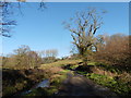
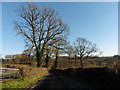
2
Water lane near Northay
The Lapswater Stream runs beside the lane to Northay, heading underneath just in front of the camera.
Image: © Derek Harper
Taken: 25 Feb 2012
0.13 miles
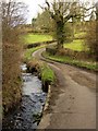
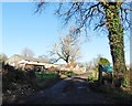
4
Northay Ford
This ford on the Lapwater Stream is found close to Waldron's Farm in Northay.
Image: © John Walton
Taken: 23 May 2016
0.15 miles
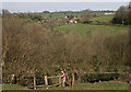
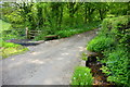
8
Rushy pasture, Waldron's Farm
From the point where the two lanes that separate in Image rejoin. The field slopes down to the Lapswater valley.
Image: © Derek Harper
Taken: 25 Feb 2012
0.24 miles