IMAGES TAKEN NEAR TO
Wadeford, CHARD, TA20 3BN
Introduction
This page details the photographs taken nearby to TA20 3BN by members of the Geograph project.
The Geograph project started in 2005 with the aim of publishing, organising and preserving representative images for every square kilometre of Great Britain, Ireland and the Isle of Man.

There are currently over 7.5m images from over14,400 individuals and you can help contribute to the project by visiting https://www.geograph.org.uk
Image Map
Images are licensed for reuse under creativecommons.org/licenses/by-sa/2.0
Notes
- Clicking on the map will re-center to the selected point.
- The higher the marker number, the further away the image location is from the centre of the postcode.
Image Listing (4 Images Found)
Images are licensed for reuse under creativecommons.org/licenses/by-sa/2.0
Image
Details
Distance
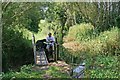
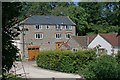
3
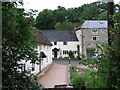
Court Mill
The early C19 former corn mill on the right, beside the River Isle, is now a dwelling. Beside it are the Mill House and mill cottage.
Image: © Derek Harper
Taken: 21 Jun 2007
0.20 miles
4
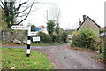
Signpost in Willhayne
This signpost to Clayhanger is on a small triangle of grass in the centre of the hamlet on Court Mill Lane. As well as the No Through Road sign there is another sign saying Private Road and listing the names of the houses on the road which leads to a small modern development of similar houses.
Image: © Nigel Mykura
Taken: 15 Nov 2020
0.23 miles