IMAGES TAKEN NEAR TO
Wadeford, CHARD, TA20 3BJ
Introduction
This page details the photographs taken nearby to TA20 3BJ by members of the Geograph project.
The Geograph project started in 2005 with the aim of publishing, organising and preserving representative images for every square kilometre of Great Britain, Ireland and the Isle of Man.

There are currently over 7.5m images from over14,400 individuals and you can help contribute to the project by visiting https://www.geograph.org.uk
Image Map
Images are licensed for reuse under creativecommons.org/licenses/by-sa/2.0
Notes
- Clicking on the map will re-center to the selected point.
- The higher the marker number, the further away the image location is from the centre of the postcode.
Image Listing (7 Images Found)
Images are licensed for reuse under creativecommons.org/licenses/by-sa/2.0
Image
Details
Distance
5
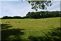
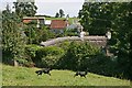
Sheep in the Sun
Recently shorn sheep with their lambs in a field close to Nimmer.
Image: © Nigel Mykura
Taken: 18 Jun 2015
0.16 miles
7
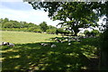
Sheep in the Shade at Nimmer
These sheep and lambs were enjoying the coolness of the shade under an oak tree just north of the minor road from Pudleigh to Clayhanger.
Image: © Nigel Mykura
Taken: 18 Jun 2015
0.22 miles