IMAGES TAKEN NEAR TO
CHARD, TA20 2TL
Introduction
This page details the photographs taken nearby to TA20 2TL by members of the Geograph project.
The Geograph project started in 2005 with the aim of publishing, organising and preserving representative images for every square kilometre of Great Britain, Ireland and the Isle of Man.

There are currently over 7.5m images from over14,400 individuals and you can help contribute to the project by visiting https://www.geograph.org.uk
Image Map
Images are licensed for reuse under creativecommons.org/licenses/by-sa/2.0
Notes
- Clicking on the map will re-center to the selected point.
- The higher the marker number, the further away the image location is from the centre of the postcode.
Image Listing (7 Images Found)
Images are licensed for reuse under creativecommons.org/licenses/by-sa/2.0
Image
Details
Distance
2
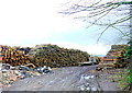
Wood Storage Yard at Copse Stile
This is a very recent addition to activity as the field appears as an arable one on Google earth. The source of the timber logs is uncertain as there are no substantial pine woods in the immediate vicinity. The copse in the title may refer to the one a short distance to the east on Paradise Lane, the road to Forton.
Image: © Nigel Mykura
Taken: 31 Dec 2015
0.12 miles
3
Crossroads at Copse Stile
This is at the junction of Paradise Lane and Bounds Lane which is the lane on the right here running down to Forton. The lane on the left goes to Chard.
Image: © Nigel Mykura
Taken: 31 Dec 2015
0.15 miles
6
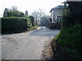
Junction of Bounds Lane and Chardstock Lane
Edencote Farm and entrance to Chardstock House.
Image: © Peter Holmes
Taken: 18 Mar 2009
0.19 miles