IMAGES TAKEN NEAR TO
Loveridge Lane, CHARD, TA20 2SE
Introduction
This page details the photographs taken nearby to Loveridge Lane, TA20 2SE by members of the Geograph project.
The Geograph project started in 2005 with the aim of publishing, organising and preserving representative images for every square kilometre of Great Britain, Ireland and the Isle of Man.

There are currently over 7.5m images from over14,400 individuals and you can help contribute to the project by visiting https://www.geograph.org.uk
Image Map
Images are licensed for reuse under creativecommons.org/licenses/by-sa/2.0
Notes
- Clicking on the map will re-center to the selected point.
- The higher the marker number, the further away the image location is from the centre of the postcode.
Image Listing (5 Images Found)
Images are licensed for reuse under creativecommons.org/licenses/by-sa/2.0
Image
Details
Distance
1
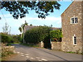
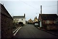
Downings Farm
The farmhouse on the right is a C19 listed building at the northern edge of Tatworth village, where House's Lane meets Tatworth Street. http://webapp1.somerset.gov.uk/her/details.asp?prn=56027
Image: © Derek Harper
Taken: 16 Sep 2006
0.11 miles
2
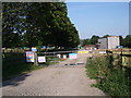
Tatworth Water Treatment Works, Forton Lane
Entrance to the Wessex Water Tatworth Water Treatment Works on Forton Lane.
Image: © Vieve Forward
Taken: 25 Jul 2012
0.20 miles
3
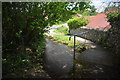
Waterlake Ford
This ford is found at Waterlake.
Image: © John Walton
Taken: 6 Jun 2017
0.20 miles
4
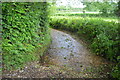
Coombses Ford
Although marked on the OS map as two fords this is one long ford of about 50 metres on the bridleway at Coombses.
Image: © John Walton
Taken: 6 Jun 2017
0.21 miles
5
Junction of Fore Street and Holway near Tatworth
Photograph taken in 1990 near Waterlake.
Image: © Clint Mann
Taken: Unknown
0.24 miles