IMAGES TAKEN NEAR TO
Post Office Lane, CHARD, TA20 2RR
Introduction
This page details the photographs taken nearby to Post Office Lane, TA20 2RR by members of the Geograph project.
The Geograph project started in 2005 with the aim of publishing, organising and preserving representative images for every square kilometre of Great Britain, Ireland and the Isle of Man.

There are currently over 7.5m images from over14,400 individuals and you can help contribute to the project by visiting https://www.geograph.org.uk
Image Map
Images are licensed for reuse under creativecommons.org/licenses/by-sa/2.0
Notes
- Clicking on the map will re-center to the selected point.
- The higher the marker number, the further away the image location is from the centre of the postcode.
Image Listing (8 Images Found)
Images are licensed for reuse under creativecommons.org/licenses/by-sa/2.0
Image
Details
Distance
1
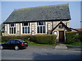
Bethel Strict Baptist Chapel
School Lane, South Chard.
Image: © Peter Holmes
Taken: 18 Mar 2009
0.02 miles
2
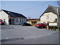
South Chard Church
In Post Office Lane http://www.southchard.org/index.html
Image: © Peter Holmes
Taken: 18 Mar 2009
0.10 miles
3
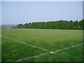
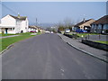
Tatworth Playing Field
A multi use games area (MUGA).
Image: © Peter Holmes
Taken: 18 Mar 2009
0.12 miles
4
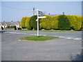
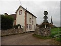
Which way now ?
Signpost at five ways crossing.
Image: © Peter Holmes
Taken: 18 Mar 2009
0.13 miles
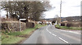
6
Kent's Lane
Designated a public footpath on the OS Explorer Map.
Image: © Peter Holmes
Taken: 18 Mar 2009
0.17 miles
8
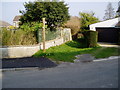
Bull's Lane
At junction with School Lane, public footpath to Waterlake Road.
Image: © Peter Holmes
Taken: 18 Mar 2009
0.24 miles