IMAGES TAKEN NEAR TO
Two Ash Hill, CHARD, TA20 2NW
Introduction
This page details the photographs taken nearby to TA20 2NW by members of the Geograph project.
The Geograph project started in 2005 with the aim of publishing, organising and preserving representative images for every square kilometre of Great Britain, Ireland and the Isle of Man.

There are currently over 7.5m images from over14,400 individuals and you can help contribute to the project by visiting https://www.geograph.org.uk
Image Map
Images are licensed for reuse under creativecommons.org/licenses/by-sa/2.0
Notes
- Clicking on the map will re-center to the selected point.
- The higher the marker number, the further away the image location is from the centre of the postcode.
Image Listing (2 Images Found)
Images are licensed for reuse under creativecommons.org/licenses/by-sa/2.0
Image
Details
Distance
1
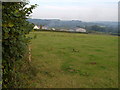
Barleclose Farm
A view from Two Ash Lane close to its junction with the A358 on Two Ash Hill.
Image: © Derek Harper
Taken: 16 Sep 2006
0.06 miles
2
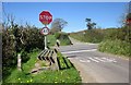
Crossroads on A358
Two Ash Lane reaches the main road, with Paradise Lane continuing on the far side.
Image: © Derek Harper
Taken: 22 Apr 2015
0.13 miles