IMAGES TAKEN NEAR TO
CHARD, TA20 1QP
Introduction
This page details the photographs taken nearby to TA20 1QP by members of the Geograph project.
The Geograph project started in 2005 with the aim of publishing, organising and preserving representative images for every square kilometre of Great Britain, Ireland and the Isle of Man.

There are currently over 7.5m images from over14,400 individuals and you can help contribute to the project by visiting https://www.geograph.org.uk
Image Map
Images are licensed for reuse under creativecommons.org/licenses/by-sa/2.0
Notes
- Clicking on the map will re-center to the selected point.
- The higher the marker number, the further away the image location is from the centre of the postcode.
Image Listing (12 Images Found)
Images are licensed for reuse under creativecommons.org/licenses/by-sa/2.0
Image
Details
Distance
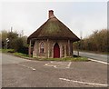
1
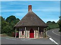
Thatched former toll house on the A30 near Chard
Image: © Neil Theasby
Taken: 9 Jul 2010
0.00 miles
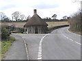
2
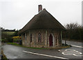
Old Toll House, Chard
Turnpike Cottage, High Street, Snowdon Hill, Chard. TA20 1QP.
Grade II listed.
List Entry Number: 1197472 https://historicengland.org.uk/listing/the-list/list-entry/1197472
Surveyed
Milestone Society National ID: SO.CHA01
Image: © Alan Rosevear
Taken: 16 Jan 2008
0.01 miles
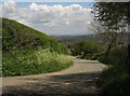
3
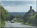
A30 on Snowdon Hill
Just west of Chard, there is a thatched cottage at the fork between the S30 and Wambrook. It was formerly a tollhouse
Image: © David Smith
Taken: 5 Jun 2014
0.01 miles
5
Old thatched toll house on A30 west of Chard
Image: © Martin Southwood
Taken: 5 Mar 2006
0.03 miles
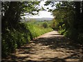
6
Lane to Turnpike Cottage
The cottage, shown in Image, can be glimpsed at the A30 junction some 170 metres away from this lane junction. The lane up to the left is shown in Image
Image: © Derek Harper
Taken: 16 May 2013
0.04 miles
7

Thatched Tollhouse
This thatched tollhouse is now a private residence and is on Snowdon Hill at the junction of the A30 (right) and a minor road (left) leading to Wambrook.
Image: © Phil Williams
Taken: 18 Sep 2005
0.05 miles
8
Lane on Snowdon Hill
Emerging from trees having just left the A30 at the junction shown in Image
Image: © Derek Harper
Taken: 16 May 2013
0.18 miles
9
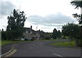
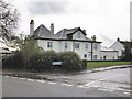
Snowdon Heights, Chard
A small residential street on the west of Chard
Image: © David Smith
Taken: 20 Aug 2019
0.20 miles