IMAGES TAKEN NEAR TO
Bondfield Way, CHARD, TA20 1LE
Introduction
This page details the photographs taken nearby to Bondfield Way, TA20 1LE by members of the Geograph project.
The Geograph project started in 2005 with the aim of publishing, organising and preserving representative images for every square kilometre of Great Britain, Ireland and the Isle of Man.

There are currently over 7.5m images from over14,400 individuals and you can help contribute to the project by visiting https://www.geograph.org.uk
Image Map
Images are licensed for reuse under creativecommons.org/licenses/by-sa/2.0
Notes
- Clicking on the map will re-center to the selected point.
- The higher the marker number, the further away the image location is from the centre of the postcode.
Image Listing (6 Images Found)
Images are licensed for reuse under creativecommons.org/licenses/by-sa/2.0
Image
Details
Distance
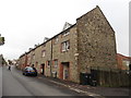
1
Morangis Way
This is a residential street on a modern housing estate on the north western outskirts of Chard. This is looking down Morangis way from close to its junction with Crimchard.
Image: © Nigel Mykura
Taken: 18 Jun 2015
0.11 miles
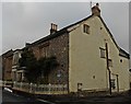
2
Old Toll House, Chard
Turnpike Cottage on Crimchard at its junction with Catchgate Lane, TA20 3PS.
Somerset HER.
HER number: 53308 https://www.heritagegateway.org.uk/Gateway/Results_Single.aspx?uid=53308&resourceID=100
Surveyed
Milestone Society National ID: SO.CHA03
Image: © Alan Rosevear
Taken: 5 Mar 2012
0.14 miles
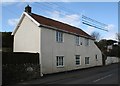
3
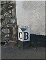
Old Boundary Marker by Crimchard, Chard Town parish
Parish Boundary Marker by the UC road, in parish of Chard Town (South Somerset District), by Turnpike Cottage, Crimchard, opposite Bews Lane, in pavement by wall of house.
Inscription reads:-
: C : : 1892 : : B :
Somerset HER.
HER number: 28296 https://www.heritagegateway.org.uk/Gateway/Results_Single.aspx?uid=28296&resourceID=100
Surveyed
Milestone Society National ID: SO_TACH12pb
Image: © Alan Rosevear
Taken: 5 Mar 2012
0.15 miles
4
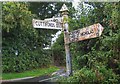
Old Direction Sign - Signpost north of Crimshaw, Combe St Nicholas Parish
Pyramid finial - 3 arms; Somerset SCC pyramid by the UC road, in parish of Combe St Nicholas (South Somerset District), crossroads, North of Crimshaw, Sorth West of Cuttiford's Door.
Surveyed
Milestone Society National ID: SO_ST3109
Image: © Milestone Society
Taken: Unknown
0.21 miles