IMAGES TAKEN NEAR TO
Fore Street, CHARD, TA20 1FE
Introduction
This page details the photographs taken nearby to Fore Street, TA20 1FE by members of the Geograph project.
The Geograph project started in 2005 with the aim of publishing, organising and preserving representative images for every square kilometre of Great Britain, Ireland and the Isle of Man.

There are currently over 7.5m images from over14,400 individuals and you can help contribute to the project by visiting https://www.geograph.org.uk
Image Map
Images are licensed for reuse under creativecommons.org/licenses/by-sa/2.0
Notes
- Clicking on the map will re-center to the selected point.
- The higher the marker number, the further away the image location is from the centre of the postcode.
Image Listing (101 Images Found)
Images are licensed for reuse under creativecommons.org/licenses/by-sa/2.0
Image
Details
Distance
2
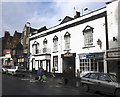
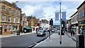
The Phoenix Hotel, Fore Street, Chard
Formerly the George Hotel - (see Image)
Image: © Roger Cornfoot
Taken: 3 Nov 2009
0.04 miles
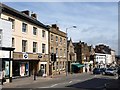
3
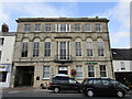
Lloyds Bank, Chard
Built as the Chard Arms Hotel 1849 https://historicengland.org.uk/listing/the-list/list-entry/1197455
Image: © Jonathan Thacker
Taken: 18 Sep 2018
0.04 miles
4
Waterloo House and the Court House
A complicated set of buildings, originally one but now subdivided. The oldest parts date from the sixteenth century. https://historicengland.org.uk/listing/the-list/list-entry/1197449
Image: © Jonathan Thacker
Taken: 18 Sep 2018
0.04 miles
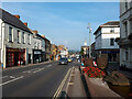
5
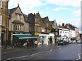
Fore Street, Chard
The wide main street of this market town.
Image: © Jonathan Billinger
Taken: 9 Sep 2022
0.05 miles
6
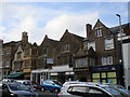
Fore Street, Chard
Interesting buildings line the northern side of Fore Street opposite Image The Nat West bank behind the traffic light dates from 1820, an attractive Ham Hill stone building with rustication to the ground floor. Next door but one is Chard's only grade 1 listed building apart from St Mary's Church, the Elizabethan Manor Court House (see http://webapp1.somerset.gov.uk/her/details.asp?prn=58181 ).
Image: © Derek Harper
Taken: 4 Apr 2008
0.05 miles
7
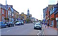
Main Street, Chard
Established before the Norman Conquest, this town has numerous historic buildings along the main road through, which is the A30 west-country road. The building with the clock tower is the Guildhall.
Image: © mike smith
Taken: 6 Aug 2013
0.05 miles
9
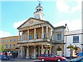
The Guildhall, Chard
The Guildhall is a Grade II* Listed Building in the centre of the town that dates back to 1837 and was formerly the Corn Exchange. The Guildhall houses the offices of Chard Town Council, but it is also a community building for a wide range of activities.
Image: © mike smith
Taken: 6 Aug 2013
0.05 miles
10
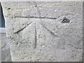
Ordnance Survey 1GL Bolt
This OS Bolt can be found on the front of the Town Hall/Guildhall. It marks a point 363.3ft above mean sea level.
Image: © Adrian Dust
Taken: 29 Mar 2015
0.05 miles