IMAGES TAKEN NEAR TO
Lower Horton, ILMINSTER, TA19 9PU
Introduction
This page details the photographs taken nearby to TA19 9PU by members of the Geograph project.
The Geograph project started in 2005 with the aim of publishing, organising and preserving representative images for every square kilometre of Great Britain, Ireland and the Isle of Man.

There are currently over 7.5m images from over14,400 individuals and you can help contribute to the project by visiting https://www.geograph.org.uk
Image Map
Images are licensed for reuse under creativecommons.org/licenses/by-sa/2.0
Notes
- Clicking on the map will re-center to the selected point.
- The higher the marker number, the further away the image location is from the centre of the postcode.
Image Listing (11 Images Found)
Images are licensed for reuse under creativecommons.org/licenses/by-sa/2.0
Image
Details
Distance
1
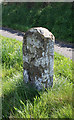
Old Milestone by the former A303, west of Horton Cross
Stone post (plate lost) by the UC road (was A303), in parish of Horton (South Somerset District), West of Horton Cross, near junction with Sugg's Lane, on wide grass verge, between road and footpath, on South side of road. Ilminster iron plate, erected by the Honiton & Ilminster turnpike trust in the 19th century.
Inscription once read:-
(ILMINSTER)
(2)
(HONITON)
(14½)
One plate above the other.
Rivet benchmark on top back.
Grade II listed.
List Entry Number: 1174847 https://historicengland.org.uk/listing/the-list/list-entry/1174847
Milestone Society National ID: SO_IMHO02
Image: © Alan Rosevear
Taken: 12 Apr 2011
0.11 miles
2
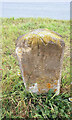
Old Milestone by the former A303, west of Horton Cross
Stone post (plate lost) by the UC road (was A303), in parish of Horton (South Somerset District), West of Horton Cross, near junction with Sugg's Lane, on wide grass verge, between road and footpath, on South side of road. Ilminster iron plate, erected by the Honiton & Ilminster turnpike trust in the 19th century.
Inscription once read:-
(ILMINSTER)
(2)
(HONITON)
(14½)
One plate above the other.
Rivet benchmark on top back.
Grade II listed.
List Entry Number: 1174847 https://historicengland.org.uk/listing/the-list/list-entry/1174847
Milestone Society National ID: SO_IMHO02
Image: © Tim Beer
Taken: 3 Sep 2024
0.11 miles
3
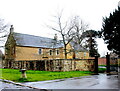
Horton Manor
On the old maps c.1900 this house is named as Horton House. The house that is now known as Horton House is closer to the village of Donyatt and is shown on the maps as being called Higher Horton Farmhouse.
Image: © Nigel Mykura
Taken: 28 Feb 2022
0.14 miles

5

Cheshay's Hill bridge over A303
The bridge carries the A358 over the A303
Image: © David Smith
Taken: 2 May 2012
0.16 miles

7

A303 heading west
The A358 heading south towards Chard and Axminster crosses the bridge.
Image: © Robin Webster
Taken: 7 Sep 2019
0.17 miles


10
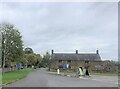
Horton Cross Farm
C17 farmhouse, listed Grade II
Image: © Eirian Evans
Taken: 28 Oct 2021
0.17 miles