IMAGES TAKEN NEAR TO
Ashill, ILMINSTER, TA19 9NQ
Introduction
This page details the photographs taken nearby to TA19 9NQ by members of the Geograph project.
The Geograph project started in 2005 with the aim of publishing, organising and preserving representative images for every square kilometre of Great Britain, Ireland and the Isle of Man.

There are currently over 7.5m images from over14,400 individuals and you can help contribute to the project by visiting https://www.geograph.org.uk
Image Map
Images are licensed for reuse under creativecommons.org/licenses/by-sa/2.0
Notes
- Clicking on the map will re-center to the selected point.
- The higher the marker number, the further away the image location is from the centre of the postcode.
Image Listing (8 Images Found)
Images are licensed for reuse under creativecommons.org/licenses/by-sa/2.0
Image
Details
Distance
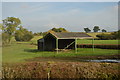
2
Ashill : Track
A track heads down to the field off the A358
Image: © Lewis Clarke
Taken: 20 Mar 2023
0.13 miles
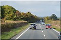
4
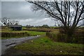
Ashill : Track
A track heading down to the field off the A358.
Image: © Lewis Clarke
Taken: 20 Mar 2023
0.14 miles
6
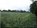
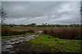
Field at Kenny
A wheatfield beside the former A358 near Ashill, which borders Venner's Water around the corner on the right. In the background is Windmill Hill.
Image: © Derek Harper
Taken: 21 Jun 2007
0.17 miles
8
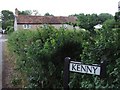
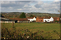
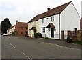
Kenny
The hamlet, consisting of a number of cottages, is at right angles to the old A358 road just northwest of Ashill.
Image: © Derek Harper
Taken: 21 Jun 2007
0.23 miles