IMAGES TAKEN NEAR TO
Catherine Wheel, ILMINSTER, TA19 9LB
Introduction
This page details the photographs taken nearby to TA19 9LB by members of the Geograph project.
The Geograph project started in 2005 with the aim of publishing, organising and preserving representative images for every square kilometre of Great Britain, Ireland and the Isle of Man.

There are currently over 7.5m images from over14,400 individuals and you can help contribute to the project by visiting https://www.geograph.org.uk
Image Map
Images are licensed for reuse under creativecommons.org/licenses/by-sa/2.0
Notes
- Clicking on the map will re-center to the selected point.
- The higher the marker number, the further away the image location is from the centre of the postcode.
Image Listing (8 Images Found)
Images are licensed for reuse under creativecommons.org/licenses/by-sa/2.0
Image
Details
Distance
1
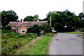
Old Toll House, Ashill
Ashill Toll House South East of Ashill at the junction of Cad Road and the old road to Horton Cross.
Somerset HER.
HER number: 45123 https://www.heritagegateway.org.uk/Gateway/Results_Single.aspx?uid=45123&resourceID=100
Surveyed
Milestone Society National ID: SO.ASH
Image: © Alan Rosevear
Taken: 12 Feb 2009
0.00 miles
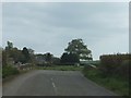
2
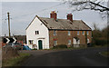
Cottage Near Shrubbery Farm
This cottage sits close to the junction of the minor road from Ilton to Broadway and the minor road to Thickthorn.
Image: © Nigel Mykura
Taken: 22 Sep 2022
0.01 miles
4
Bow Bridge
A well-built stone bridge over a small stream
Image: © David Smith
Taken: 2 May 2012
0.13 miles
5

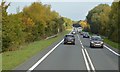
South Somerset : The A358
Looking along the A358.
Image: © Lewis Clarke
Taken: 30 Sep 2018
0.14 miles
6

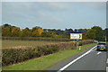
A358 Leading to the end of the rainbow
Well actually leading to the A303 at Horton Cross.
Image: © Steve Barnes
Taken: 1 Sep 2009
0.14 miles
7

South Somerset : Cad Road
Looking along Cad Road off of the A358.
Image: © Lewis Clarke
Taken: 30 Sep 2018
0.19 miles