IMAGES TAKEN NEAR TO
ILMINSTER, TA19 9DT
Introduction
This page details the photographs taken nearby to TA19 9DT by members of the Geograph project.
The Geograph project started in 2005 with the aim of publishing, organising and preserving representative images for every square kilometre of Great Britain, Ireland and the Isle of Man.

There are currently over 7.5m images from over14,400 individuals and you can help contribute to the project by visiting https://www.geograph.org.uk
Image Map
Images are licensed for reuse under creativecommons.org/licenses/by-sa/2.0
Notes
- Clicking on the map will re-center to the selected point.
- The higher the marker number, the further away the image location is from the centre of the postcode.
Image Listing (8 Images Found)
Images are licensed for reuse under creativecommons.org/licenses/by-sa/2.0
Image
Details
Distance
1
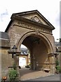
Dillington House
Another view of the west facade of Image Architectural details at http://webapp1.somerset.gov.uk/her/details.asp?prn=56603 , and notes on its use during World War Two at http://webapp1.somerset.gov.uk/her/details.asp?prn=15029 .
Image: © Derek Harper
Taken: 10 Jul 2007
0.01 miles
2
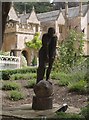
Sculpture at Dillington House
The wooden figure (unable to trace any details so far) is beside footpath CH14/14 as it passes Dillington House in the background, and is one of several pieces of artwork in the grounds, doubtless related to the many art-related courses run at the centre.
Image: © Derek Harper
Taken: 10 Jul 2007
0.03 miles
3

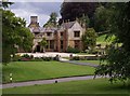
Dillington House
The attractive front and gardens of Dillington House, an education centre in Somerset
Image: © Roger May
Taken: 8 Feb 2005
0.05 miles
4
The Mews, Dillington House
The former stable block at Image dates from a later era. See
http://webapp1.somerset.gov.uk/her/details.asp?prn=56602
Image: © Derek Harper
Taken: 10 Jul 2007
0.05 miles
5
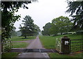
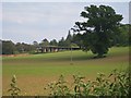
Cattle grid, Dillington House
The drive through the east side of Dillington Park is followed by NCN cycle route 33, and a public footpath to Whitelackington. The cattle grid marks the edge of the formal gardens surrounding Image
Image: © Derek Harper
Taken: 13 May 2009
0.06 miles
6
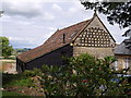
The Pheasantry
One of the outbuildings at Dillington House. (Those holes look more suitable for doves than pheasants, although this building may date from between the C17 extinction of the bird and its reintroduction in the C19.)
Image: © Derek Harper
Taken: 10 Jul 2007
0.07 miles
7
Field behind Ashwell
Looking over the field towards the back of Dillington where there is a long modern building with grass growing on its roof.
Image: © Sarah Smith
Taken: 7 Jun 2013
0.16 miles
8
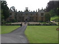
Dillington House
Present house dates back to the 16th Century. Now a regional centre for adult education and the arts.
Image: © Liz Martin
Taken: 20 May 2005
0.17 miles