IMAGES TAKEN NEAR TO
West Street, ILMINSTER, TA19 9AA
Introduction
This page details the photographs taken nearby to West Street, TA19 9AA by members of the Geograph project.
The Geograph project started in 2005 with the aim of publishing, organising and preserving representative images for every square kilometre of Great Britain, Ireland and the Isle of Man.

There are currently over 7.5m images from over14,400 individuals and you can help contribute to the project by visiting https://www.geograph.org.uk
Image Map
Images are licensed for reuse under creativecommons.org/licenses/by-sa/2.0
Notes
- Clicking on the map will re-center to the selected point.
- The higher the marker number, the further away the image location is from the centre of the postcode.
Image Listing (110 Images Found)
Images are licensed for reuse under creativecommons.org/licenses/by-sa/2.0
Image
Details
Distance
1
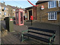
Between West Street and High Street
A sliver of land between the two main roads is occupied by some municipal items, the Gospel Hall and a large Santa. For sake of completion, the telephone box does have a telephone in it.
Image: © Neil Owen
Taken: 9 Dec 2022
0.01 miles
2
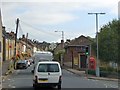
Traffic in Ilminster High Street
The building on the right is a gospel hall; hopefully it is soundproofed against traffic noise
Image: © David Smith
Taken: 2 Oct 2014
0.02 miles
3
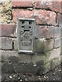
West Street Ilminster, OS Flush Bracket Benchmark
This is a flush bracket benchmark, 0.3m above the ground and 53.14m above Ordnance Datum Newlyn (Tide Gauge Bolt Newlyn Pier - the authoritative datum for the UK). It was last verified in 1952. Grid ref: ST 3584 1471. Description: FL BR 1687 BLDG NO31 WEST ST N FACE 1.5M E PRODN.
www.geograph.org.uk/photo/6570302
Image: © Meg Hepworth
Taken: 15 Aug 2020
0.04 miles
4
West Street, Ilminster - Flush Bracket OS Benchmark
This is a flush bracket benchmark, 0.3m above the ground and 53.14m above Ordnance Datum Newlyn (Tide Gauge Bolt Newlyn Pier - the authoritative datum for the UK). It was last verified in 1952. Grid ref: ST 3584 1471. Description: FL BR 1687 BLDG NO31 WEST ST N FACE 1.5M E PRODN.
Link to close up photo: www.geograph.org.uk/photo/6570288
Image: © Meg Hepworth
Taken: 15 Aug 2020
0.04 miles
5
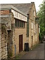
Warehouse Theatre, Ilminster
In a former fruit and vegetable warehouse on Brewery Lane, this doubles as a cinema.
Image: © Derek Harper
Taken: 13 May 2009
0.04 miles
6
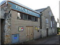
The Warehouse Theatre
Ilminster's theatrical heart in Brewery Lane, operating since the end of WWII. The associated buildings were indeed a brewery previously.
Image: © Neil Owen
Taken: 9 Dec 2022
0.04 miles
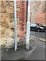
7
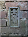
Ilminster, West Street flush bracket
A flush bracket set in the wall of the old Brewery Inn. See https://www.bench-marks.org.uk/bm2864 for the entry in the Benchmark Database and Image] for a wider view.
Image: © Neil Owen
Taken: 9 Dec 2022
0.04 miles
8
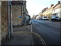
Along West Street
A view westwards along Ilminster's main road, with a flush bracket set into the wall close to the poles - the only one left in Ilminster. See Image
Image: © Neil Owen
Taken: 9 Dec 2022
0.04 miles
9
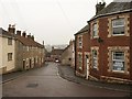
Silver Street, Ilminster
The street drops downhill from West Street (right) before bending left past Image
Image: © Derek Harper
Taken: 13 May 2009
0.05 miles
10
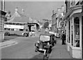
Ilminster: westward from East Street, past Market Hall
Little has changed since 1960 - except of course the road vehicles.
Image: © Ben Brooksbank
Taken: 24 Apr 1960
0.07 miles