IMAGES TAKEN NEAR TO
Sea, ILMINSTER, TA19 0SB
Introduction
This page details the photographs taken nearby to TA19 0SB by members of the Geograph project.
The Geograph project started in 2005 with the aim of publishing, organising and preserving representative images for every square kilometre of Great Britain, Ireland and the Isle of Man.

There are currently over 7.5m images from over14,400 individuals and you can help contribute to the project by visiting https://www.geograph.org.uk
Image Map (Loading...)


Getting Data...Please wait
Leaflet Map data © OpenStreetMap
Images are licensed for reuse under creativecommons.org/licenses/by-sa/2.0
Notes
- Clicking on the map will re-center to the selected point.
- The higher the marker number, the further away the image location is from the centre of the postcode.
Image Listing (4 Images Found)
Images are licensed for reuse under creativecommons.org/licenses/by-sa/2.0
Image
Details
Distance
1
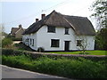
Thatched farmhouse at Sea
The grid line runs along the road at Sea, and this farmhouse is on the south side. Sea probably means island, and the presence of sandbags at some doorways indicates the likelihood of flooding here.
Image: © Derek Harper
Taken: 22 Apr 2006
0.12 miles
3
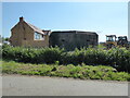
Applewood Nursery
This nursery appears to occupy the buildings that were once Sea Dairy Farm
Image: © Nigel Mykura
Taken: 28 Feb 2022
0.17 miles