IMAGES TAKEN NEAR TO
Kingstone Cross, ILMINSTER, TA19 0NU
Introduction
This page details the photographs taken nearby to Kingstone Cross, TA19 0NU by members of the Geograph project.
The Geograph project started in 2005 with the aim of publishing, organising and preserving representative images for every square kilometre of Great Britain, Ireland and the Isle of Man.

There are currently over 7.5m images from over14,400 individuals and you can help contribute to the project by visiting https://www.geograph.org.uk
Image Map
Images are licensed for reuse under creativecommons.org/licenses/by-sa/2.0
Notes
- Clicking on the map will re-center to the selected point.
- The higher the marker number, the further away the image location is from the centre of the postcode.
Image Listing (30 Images Found)
Images are licensed for reuse under creativecommons.org/licenses/by-sa/2.0
Image
Details
Distance
1
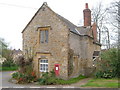
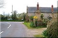
Old Toll House, Kingstone
http://webapp1.somerset.gov.uk/her/details.asp?prn=57243 . George V postbox TA19 19 is on the wall. See also Image
Image: © Derek Harper
Taken: 22 Apr 2006
0.04 miles
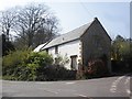
3
Old Toll House, Kingstone
Image http://webapp1.somerset.gov.uk/her/details.asp?prn=57243 seen from another direction. George V postbox TA19 19 is on the wall. The lane to the left is for Moolham, with a turn to Dowlish Wake; the main road id for Ilminster. NCN30 turns here.
Image: © Derek Harper
Taken: 22 Apr 2006
0.05 miles
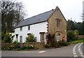
4
Old Toll House, Kingstone
Toll House in the parish of Dowlish Wake, Turnpike Cottage, Kingstone Gate, Kingstone Hill, TA19 0NS.
Grade II listed.
List Entry Number: 1307443 https://historicengland.org.uk/listing/the-list/list-entry/1307443
Surveyed
Milestone Society National ID: SO.DOW
Image: © Alan Rosevear
Taken: 29 Aug 2009
0.05 miles
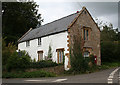
5
Junction, Kingstone
The junction and toll house seen in Image], from a different angle.
Image: © Derek Harper
Taken: 22 Apr 2006
0.05 miles
6
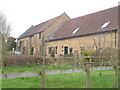
Barn conversion, Kingstone Farmhouse
The pre-conversion photo, taken in 1986, at http://webapp1.somerset.gov.uk/her/details.asp?prn=56718 makes an interesting comparison. Listed and described at https://historicengland.org.uk/listing/the-list/list-entry/1056989 .
Image: © Derek Harper
Taken: 22 Apr 2006
0.09 miles
7
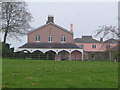
Wake Hill, Kingstone
Early C19 house - "in a later form of 'cottage ornee' (http://webapp1.somerset.gov.uk/her/details.asp?prn=57246 )
Image: © Derek Harper
Taken: 22 Apr 2006
0.12 miles
8
Path to Kingstone
Footpath CH 12/15 passes some trees in the midst of a large field of oilseed rape, with Image ahead.
Image: © Derek Harper
Taken: 22 Apr 2006
0.14 miles
9
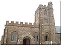
St John and All Saints church, Kingstone
The medieval church http://webapp1.somerset.gov.uk/her/details.asp?prn=56710 from the south.
Image: © Derek Harper
Taken: 22 Apr 2006
0.14 miles
10
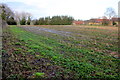
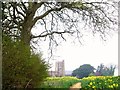
Field at Kingstone
The small village of Kingstone sits at the top of Kingstone Hill on the minor road from Ilminster to Dowlish Wake.
Image: © Nigel Mykura
Taken: 24 Jan 2018
0.16 miles