IMAGES TAKEN NEAR TO
West End View, ILMINSTER, TA19 0JQ
Introduction
This page details the photographs taken nearby to West End View, TA19 0JQ by members of the Geograph project.
The Geograph project started in 2005 with the aim of publishing, organising and preserving representative images for every square kilometre of Great Britain, Ireland and the Isle of Man.

There are currently over 7.5m images from over14,400 individuals and you can help contribute to the project by visiting https://www.geograph.org.uk
Image Map
Images are licensed for reuse under creativecommons.org/licenses/by-sa/2.0
Notes
- Clicking on the map will re-center to the selected point.
- The higher the marker number, the further away the image location is from the centre of the postcode.
Image Listing (5 Images Found)
Images are licensed for reuse under creativecommons.org/licenses/by-sa/2.0
Image
Details
Distance
1
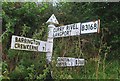
Old Direction Sign - Signpost by the B3168, West End View, Barrington
Pyramid finial - 3 arms; Somerset SCC pyramid by the B3168, in parish of Barrington (South Somerset District), junction with Highfields at West End View.
Surveyed
Milestone Society National ID: SO_ST3818
Image: © Milestone Society
Taken: Unknown
0.03 miles
2
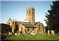
Barrington: church
St Mary’s church stands above much of the village and dates from the 13th century. With an octagonal crossing tower and transepts the church was nevertheless a subsidiary foundation to South Petherton
Image: © Martin Bodman
Taken: Unknown
0.10 miles
3
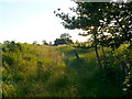
Track off Ruskway Lane
This very little used and overgrown farm track leads to some small farm buildings just visible in the distance.
Image: © Nigel Mykura
Taken: 22 Jul 2012
0.18 miles
4
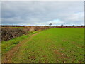
Footpath off Ruskway Lane
This footpath runs to Barrington Village and on the map runs across the field but here it appears to follow the edge of the field.
Image: © Nigel Mykura
Taken: 31 Jan 2022
0.23 miles
5
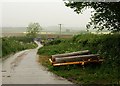
Clay Lane
Clay Lane leads off the B3168 at the eastern edge of Puckington. Farm buildings at Clay Barn can be seen. The lane also leads to a gas governor station. It's raining.
Image: © Derek Harper
Taken: 14 May 2009
0.24 miles