IMAGES TAKEN NEAR TO
The Mead, ILMINSTER, TA19 0HB
Introduction
This page details the photographs taken nearby to The Mead, TA19 0HB by members of the Geograph project.
The Geograph project started in 2005 with the aim of publishing, organising and preserving representative images for every square kilometre of Great Britain, Ireland and the Isle of Man.

There are currently over 7.5m images from over14,400 individuals and you can help contribute to the project by visiting https://www.geograph.org.uk
Image Map (Loading...)


Getting Data...Please wait
Leaflet Map data © OpenStreetMap
Images are licensed for reuse under creativecommons.org/licenses/by-sa/2.0
Notes
- Clicking on the map will re-center to the selected point.
- The higher the marker number, the further away the image location is from the centre of the postcode.
Image Listing (16 Images Found)
Images are licensed for reuse under creativecommons.org/licenses/by-sa/2.0
Image
Details
Distance
1
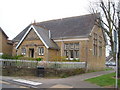
Ilminster Library
On Ditton Road, south of the town centre. The tablet in the gable reads "The Reading Room, 1889".
Image: © Derek Harper
Taken: 22 Apr 2006
0.11 miles
2
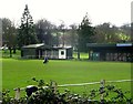
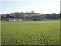
The Recreation Ground, home of Ilminster Town FC
The team play in the Somerset County League.
Image: © nick macneill
Taken: 9 Mar 2013
0.12 miles
4
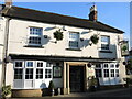
The Royal Oak, Ilminster
A pub and live music venue near the centre of town.
Image: © Neil Owen
Taken: 9 Dec 2022
0.14 miles
5
Ilminster Recreation Ground
The town's expansive grounds, with several pavilions and other associated buildings.
Image: © Neil Owen
Taken: 9 Dec 2022
0.16 miles
6
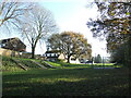
West Crescent park
A narrow corridor marks the edge of town and hosts a little play area for the children. The steep slope is actually part of the old Chard Canal and there was a short tunnel in this section.
Image: © Neil Owen
Taken: 9 Dec 2022
0.16 miles
7
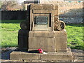
School memorial
This edifice was dedicated to the young men of the old school who fell in the Great War and also to their headmaster, who died in 1920.
Image: © Neil Owen
Taken: 9 Dec 2022
0.18 miles
8
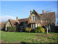
The old school in Ilminster
The original buildings in Swanmead date from the nineteenth century and are now beside the much newer Hearne View school.
Image: © Neil Owen
Taken: 9 Dec 2022
0.18 miles
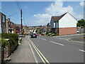
9
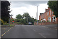
Junctions on Lister's Hill
The southern part of Ilminster.
Image: © J.Hannan-Briggs
Taken: 3 Aug 2014
0.19 miles
10
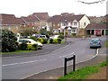
Housing south of Ilminster
Heron Way, with Little Lester the cul-de-sac leading off it. Housing dating from the late 1990s.
Image: © Derek Harper
Taken: 22 Apr 2006
0.19 miles