IMAGES TAKEN NEAR TO
Birds Close, Middle Path, CREWKERNE, TA18 8BQ
Introduction
This page details the photographs taken nearby to Birds Close, Middle Path, TA18 8BQ by members of the Geograph project.
The Geograph project started in 2005 with the aim of publishing, organising and preserving representative images for every square kilometre of Great Britain, Ireland and the Isle of Man.

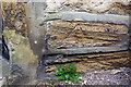
There are currently over 7.5m images from over14,400 individuals and you can help contribute to the project by visiting https://www.geograph.org.uk
Image Map
Images are licensed for reuse under creativecommons.org/licenses/by-sa/2.0
Notes
- Clicking on the map will re-center to the selected point.
- The higher the marker number, the further away the image location is from the centre of the postcode.
Image Listing (228 Images Found)
Images are licensed for reuse under creativecommons.org/licenses/by-sa/2.0
Image
Details
Distance
1
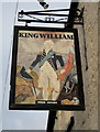
The King William Inn sign, Barn Street, Crewkerne
William of Orange stayed in Crewkerne on his journey to London but this looks more like William IV "the Sailor King".
Image: © Sarah Smith
Taken: 28 Jan 2009
0.05 miles
3
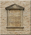
Endowment tablet, Chubb's Almshouses, Crewkerne
"In the Jubilee Year of the reign of Her Majesty Queen Victoria, on June 20th 1887, the inhabitants of Crewkerne raised by voluntary subscription the sum of £369.15.9, which was invested, £366.11.6. 3-and-a-half per cent India stock, and was added to the endowment fund." For the building, see: http://www.geograph.org.uk/photo/5632367 .
Image: © Bill Harrison
Taken: 11 Jul 2016
0.05 miles
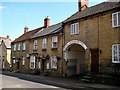
4
Houses on West Street at A30 junction
There is an OS benchmark Image on the corner of the nearest house, left of the no entry sign
Image: © Roger Templeman
Taken: 30 Mar 2015
0.06 miles
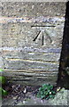
5
Benchmark on #48 West Street
Ordnance Survey cut mark benchmark described on the Bench Mark Database at http://www.bench-marks.org.uk/bm65523
Image: © Roger Templeman
Taken: 30 Mar 2015
0.06 miles
6
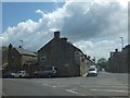
Chard road Crewkerne
The road joins the one way system here bearing to the left
Image: © John Firth
Taken: 12 Apr 2013
0.06 miles
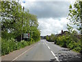
7
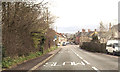
Start of the traffic gyratory system in Crewkerne
On the west side of Crewkerne, traffic follows a lengthy one-way system through the narrow urban streets. This is the start for eastbound traffic on the A30 (West Street) with the left fork to Gouldsbrook Terrace
Image: © David Smith
Taken: 5 Jun 2014
0.06 miles
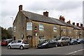
8
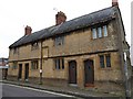
Chubb's Almshouses, Crewkerne
Another view of Image from the junction of Court Barton with West Street. This is the earlier of two four-unit blocks. http://www.imagesofengland.org.uk/Details/Default.aspx?id=390446&mode=adv
Image: © Derek Harper
Taken: 15 Sep 2009
0.06 miles
9
West Street Crewkerne
The lettering over the coach entrance has been restored showing the advertising of the trade of a former occupant. It says "J A HOARE Coach Builder & Wheelwright Carpenter Black & Bright Smith Locks of All Kinds Repaired".
Image: © Sarah Smith
Taken: 23 Jul 2008
0.06 miles
10
Benchmark on West One Surgery
Ordnance Survey cut mark benchmark described on the Bench Mark Database at http://www.bench-marks.org.uk/bm57201
Image: © Roger Templeman
Taken: 30 Mar 2015
0.06 miles