IMAGES TAKEN NEAR TO
Lye Water, CREWKERNE, TA18 8BB
Introduction
This page details the photographs taken nearby to Lye Water, TA18 8BB by members of the Geograph project.
The Geograph project started in 2005 with the aim of publishing, organising and preserving representative images for every square kilometre of Great Britain, Ireland and the Isle of Man.

There are currently over 7.5m images from over14,400 individuals and you can help contribute to the project by visiting https://www.geograph.org.uk
Image Map
Images are licensed for reuse under creativecommons.org/licenses/by-sa/2.0
Notes
- Clicking on the map will re-center to the selected point.
- The higher the marker number, the further away the image location is from the centre of the postcode.
Image Listing (154 Images Found)
Images are licensed for reuse under creativecommons.org/licenses/by-sa/2.0
Image
Details
Distance
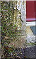
1
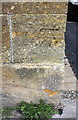
Benchmark on #2 Lyewater
Ordnance Survey cut mark benchmark described on the Bench Mark Database at http://www.bench-marks.org.uk/bm65525
Image: © Roger Templeman
Taken: 30 Mar 2015
0.02 miles
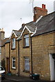
2
#2 Lyewater
There is an OS benchmark Image on the near corner, road face, of the house
Image: © Roger Templeman
Taken: 30 Mar 2015
0.03 miles
3
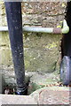
Benchmark behind pipe on #75 West Street
Ordnance Survey cut mark benchmark described on the Bench Mark Database at http://www.bench-marks.org.uk/bm65526
Image: © Roger Templeman
Taken: 30 Mar 2015
0.03 miles
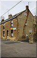
4
'ARFUP TILL', and neighbouring houses, West Street
There is an OS benchmark Image on the corner of the nearest house, on the road face between the downpipe and wheelie bin
Image: © Roger Templeman
Taken: 30 Mar 2015
0.03 miles
5
Benchmark on #49 Barn Street
Ordnance Survey cut mark benchmark described on the Bench Mark Database at http://www.bench-marks.org.uk/bm65527
Image: © Roger Templeman
Taken: 30 Mar 2015
0.08 miles
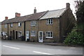
6
Barn Street houses
There is an OS benchmark Image left of the doorway at the left hand edge of the image
Image: © Roger Templeman
Taken: 30 Mar 2015
0.08 miles
7
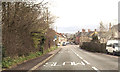
Chard road Crewkerne
The road joins the one way system here bearing to the left
Image: © John Firth
Taken: 12 Apr 2013
0.08 miles
8
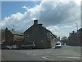
Start of the traffic gyratory system in Crewkerne
On the west side of Crewkerne, traffic follows a lengthy one-way system through the narrow urban streets. This is the start for eastbound traffic on the A30 (West Street) with the left fork to Gouldsbrook Terrace
Image: © David Smith
Taken: 5 Jun 2014
0.08 miles
9
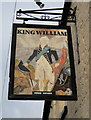
The King William Inn sign, Barn Street, Crewkerne
William of Orange stayed in Crewkerne on his journey to London but this looks more like William IV "the Sailor King".
Image: © Sarah Smith
Taken: 28 Jan 2009
0.09 miles
10
'The Old Parsonage' at the Tower Hill Road / Barn Street junction
There is an OS benchmark Image on the corner of the house partly behind the black downpipe
Image: © Roger Templeman
Taken: 30 Mar 2015
0.09 miles