IMAGES TAKEN NEAR TO
Highfield, CREWKERNE, TA18 7QE
Introduction
This page details the photographs taken nearby to Highfield, TA18 7QE by members of the Geograph project.
The Geograph project started in 2005 with the aim of publishing, organising and preserving representative images for every square kilometre of Great Britain, Ireland and the Isle of Man.

There are currently over 7.5m images from over14,400 individuals and you can help contribute to the project by visiting https://www.geograph.org.uk
Image Map (Loading...)


Getting Data...Please wait
Leaflet Map data © OpenStreetMap
Images are licensed for reuse under creativecommons.org/licenses/by-sa/2.0
Notes
- Clicking on the map will re-center to the selected point.
- The higher the marker number, the further away the image location is from the centre of the postcode.
Image Listing (27 Images Found)
Images are licensed for reuse under creativecommons.org/licenses/by-sa/2.0
Image
Details
Distance

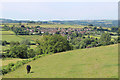
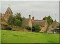
2
West Chinnock
A view of the village of West Chinnock from Balham Hill near Chiselborough.
Note the flooded fields and the course of Chinnock Brook just below them.
The flooding is quite usual and in this case followed a couple of wet months
and some 20cms of snow which had recently thawed.
Image: © Andy Pearce
Taken: 11 Feb 2009
0.09 miles
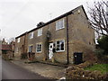
3
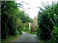
Snails Hill - West Chinnock
If skirting along the back of the village to reach the A356, Duckpool Lane will continue down the steep Snails Hill to the junction with Scotts Way and on to the main road. The way is narrow and the cottages cling to the side of the hill.
Image: © Sarah Smith
Taken: 13 Sep 2009
0.10 miles
5
Direction Sign - Signpost at Snails Hill
Lost finial - 2 arms; SCC Modern by the UC road, in parish of West Chinnock (South Somerset District), junction of Snail's Hill, Scott's Way and Duckpool Lane.
Surveyed
Milestone Society National ID: SO_ST4613A
Image: © J Dowding
Taken: Unknown
0.15 miles
6
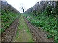
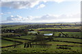
Long Lane
A view up Long Lane from West Chinnock before it makes a right turn towards the trig point. Long Lane is used to access farmland on West Chinnock Hill.
Image: © Rude Health
Taken: 29 Mar 2015
0.17 miles
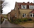
8
West Chinnock
Approaching the village on the footpath mentioned in Image On the left is the saddleback tower of Image http://www.imagesofengland.org.uk/Details/Default.aspx?id=263763&mode=adv . The two C17 thatched cottages in the centre, Tree Cottage ( http://www.imagesofengland.org.uk/Details/Default.aspx?id=263782&mode=adv ) and the Old School House ( http://www.imagesofengland.org.uk/details/default.aspx?id=263779 ), are either side of Higher Street.
Image: © Derek Harper
Taken: 15 Sep 2009
0.19 miles