IMAGES TAKEN NEAR TO
East Lane, CREWKERNE, TA18 7QB
Introduction
This page details the photographs taken nearby to East Lane, TA18 7QB by members of the Geograph project.
The Geograph project started in 2005 with the aim of publishing, organising and preserving representative images for every square kilometre of Great Britain, Ireland and the Isle of Man.

There are currently over 7.5m images from over14,400 individuals and you can help contribute to the project by visiting https://www.geograph.org.uk
Image Map (Loading...)


Getting Data...Please wait
Leaflet Map data © OpenStreetMap
Images are licensed for reuse under creativecommons.org/licenses/by-sa/2.0
Notes
- Clicking on the map will re-center to the selected point.
- The higher the marker number, the further away the image location is from the centre of the postcode.
Image Listing (34 Images Found)
Images are licensed for reuse under creativecommons.org/licenses/by-sa/2.0
Image
Details
Distance
1
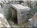
Well at West Chinnock
This well is on an island in the middle of a road junctionImage
Image: © Andy Pearce
Taken: 6 Jun 2008
0.02 miles
2
Well, West Chinnock
There is a benchmark on this well. See Image
Image: © Becky Williamson
Taken: 28 Jan 2015
0.03 miles
3
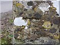
Benchmark on well, West Chinnock
Ordnance Survey benchmark, described on database at http://www.bench-marks.org.uk/bm63827. See also Image
Image: © Becky Williamson
Taken: 28 Jan 2015
0.03 miles
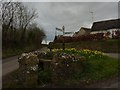
4
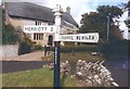
Direction Sign - Signpost in West Chinnock
Located on a raised grass triangle in the centre of the junction of Duckpool Lane, Higher Street and East Lane in West Chinnock parish. 3 arms and pyramid finial. See also http://www.flickr.com/photos/tollhouses/5615740841/ and https://www.geograph.org.uk/photo/6126415.
Milestone Society National ID: SO_ST4613
Image: © Alan Rosevear
Taken: 12 Apr 2011
0.04 miles
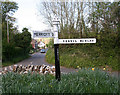
5
Direction Sign ? Signpost at West Chinnock
Located on a raised grass triangle in the centre of the junction of Duckpool Lane, Higher Street and East Lane in West Chinnock parish. 3 arms and pyramid finial. See also http://www.flickr.com/photos/tollhouses/5615740841/ and https://www.geograph.org.uk/photo/6049784.
Milestone Society National ID: SO_ST4613
Image: © Milestone Society
Taken: Unknown
0.04 miles
6
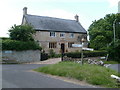
Road Junction at South End of West Chinnock
Duckpool Lane goes off to the left, High Street goes to the left
and East Lane is behind me. The stone construction to the left of
the sign post is a wall round a well.
Image: © Andy Pearce
Taken: 6 Jun 2008
0.04 miles